Project Information
| Code | MIRSAC-PRJ-15 |
|---|---|
| Category | Geosciences & Disaster Management |
| Time Period | September 2007 |
| Funding Agency | Mizoram Remote Sensing Application Centre (MRSAC) |
Landslides in Mizoram
Landslide
Disaster management
Hazard
Geology
Spatial planning
Project Description
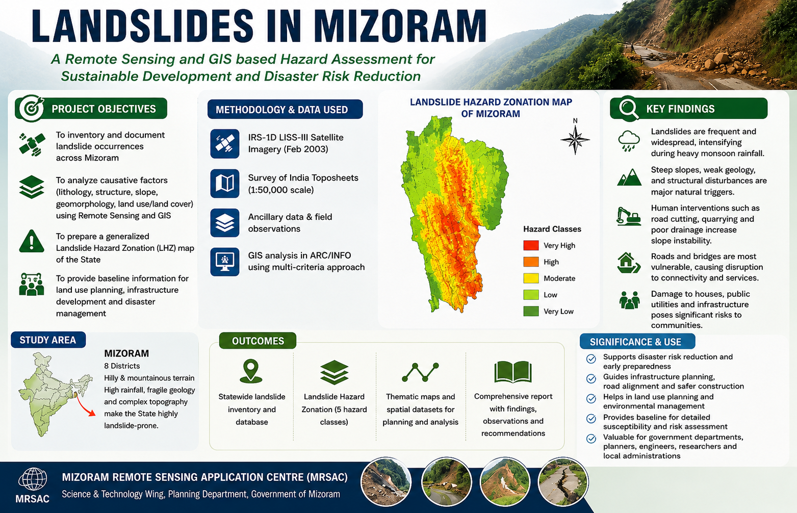
The Report on Landslides in Mizoram, prepared by the Mizoram Remote Sensing Application Centre (MRSAC) under the Science and Technology Wing, Planning Department, Government of Mizoram, was compiled in 2007 in response to the increasing incidence of landslides and associated disruptions across the State's mountainous terrain. The study was undertaken to document recent landslide occurrences, assess their geographical distribution and impacts, and provide an initial scientific understanding of landslide susceptibility across Mizoram, particularly following intense monsoon rainfall during September 2007.
The project employed Remote Sensing and Geographic Information System (GIS) techniques to prepare a generalized Landslide Hazard Zonation (LHZ) map for the State. IRS-1D LISS-III satellite imagery acquired in February 2003, together with Survey of India topographic maps at 1:50,000 scale and available ancillary spatial datasets, was used to analyse terrain and geo-environmental conditions. Key causative parameters—including lithology, geological structure, geomorphology, slope, and land use/land cover—were integrated using ARC/INFO GIS software to classify Mizoram into five relative landslide hazard categories. The analysis provided a statewide framework for identifying areas of varying susceptibility and understanding the influence of both natural terrain conditions and human interventions such as road cutting and quarrying.
The report also compiled field and administrative information on landslide impacts from across all eight districts of Mizoram, documenting damage to houses, roads, bridges, public utilities, and communication networks. The assessment highlights the vulnerability of settlements and infrastructure during periods of intense rainfall and demonstrates the widespread nature of landslide-related hazards in the State.
A key outcome of the project was the preparation of a generalized Landslide Hazard Zonation Map of Mizoram, providing an important baseline for disaster preparedness and mitigation. The report emphasizes that although landslides cannot be completely prevented, their impacts can be reduced through appropriate land-use planning, slope stabilization, safer infrastructure development, and avoidance of highly susceptible areas.
The resulting landslide inventory, hazard zonation map, spatial information, and documented observations provide valuable reference material for government departments, disaster management authorities, planners, engineers, researchers, and local administrations. The information can support road and infrastructure planning, hazard monitoring, emergency preparedness, environmental management, and prioritization of mitigation measures, while also providing a foundation for more detailed, site-specific landslide susceptibility and risk assessments in the future.
Summarize Metadata
Mapping Scale: 1:50,000
Satellite data & Year: IRS 1D LISS III (2003)
Study area: Mizoram
Collaborating/Funding Agency: Mizoram Remote Sensing Application Centre
No. of Report(s) published: 1
Project Period: 2007
The project employed Remote Sensing and Geographic Information System (GIS) techniques to prepare a generalized Landslide Hazard Zonation (LHZ) map for the State. IRS-1D LISS-III satellite imagery acquired in February 2003, together with Survey of India topographic maps at 1:50,000 scale and available ancillary spatial datasets, was used to analyse terrain and geo-environmental conditions. Key causative parameters—including lithology, geological structure, geomorphology, slope, and land use/land cover—were integrated using ARC/INFO GIS software to classify Mizoram into five relative landslide hazard categories. The analysis provided a statewide framework for identifying areas of varying susceptibility and understanding the influence of both natural terrain conditions and human interventions such as road cutting and quarrying.
The report also compiled field and administrative information on landslide impacts from across all eight districts of Mizoram, documenting damage to houses, roads, bridges, public utilities, and communication networks. The assessment highlights the vulnerability of settlements and infrastructure during periods of intense rainfall and demonstrates the widespread nature of landslide-related hazards in the State.
A key outcome of the project was the preparation of a generalized Landslide Hazard Zonation Map of Mizoram, providing an important baseline for disaster preparedness and mitigation. The report emphasizes that although landslides cannot be completely prevented, their impacts can be reduced through appropriate land-use planning, slope stabilization, safer infrastructure development, and avoidance of highly susceptible areas.
The resulting landslide inventory, hazard zonation map, spatial information, and documented observations provide valuable reference material for government departments, disaster management authorities, planners, engineers, researchers, and local administrations. The information can support road and infrastructure planning, hazard monitoring, emergency preparedness, environmental management, and prioritization of mitigation measures, while also providing a foundation for more detailed, site-specific landslide susceptibility and risk assessments in the future.
Summarize Metadata
Mapping Scale: 1:50,000
Satellite data & Year: IRS 1D LISS III (2003)
Study area: Mizoram
Collaborating/Funding Agency: Mizoram Remote Sensing Application Centre
No. of Report(s) published: 1
Project Period: 2007
Related Publications
1