Project Information
| Code | MIRSAC-PRJ-16 |
|---|---|
| Category | Forestry & Environment |
| Time Period | January 2006 |
| Funding Agency | Mizoram Remote Sensing Application Centre (MRSAC) |
Mapping of Forest Administrative Boundary of Mizoram
Forests
Administrative boundary
Forest Boundary
Project Description
The Mapping of Forest Administrative Boundary of Mizoram using Remote Sensing and GIS was undertaken as an in-house project of the Mizoram Remote Sensing Application Centre (MRSAC) under the Science & Technology, Planning Department, Government of Mizoram, and was included in the Centre's Annual Plan for 2007–08. The project was conceived in recognition of the critical ecological and socio-economic importance of Mizoram's forests and the need for an accurate, standardized, and spatially referenced delineation of the administrative framework responsible for their conservation, management, and sustainable utilization.
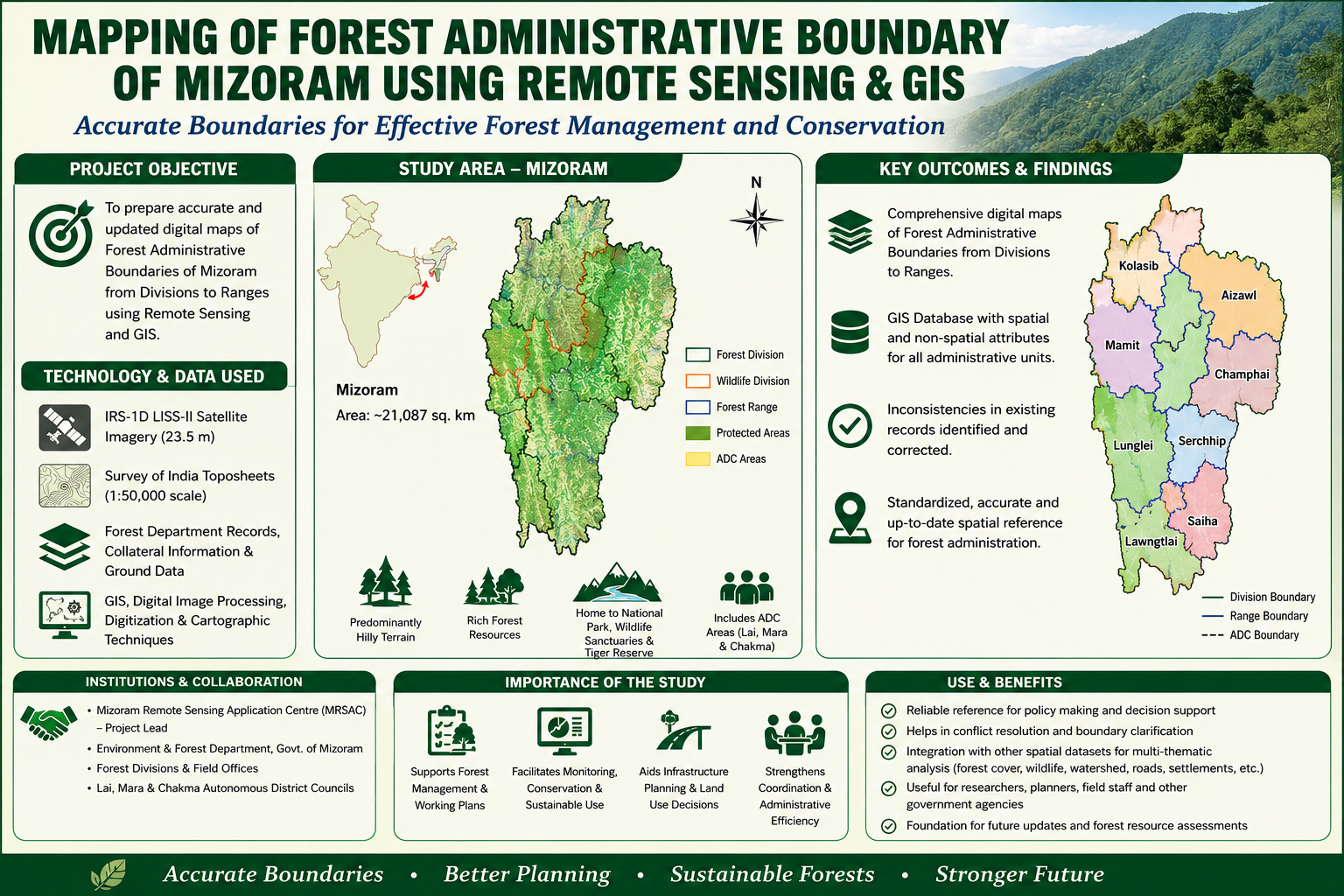
The primary objective was to prepare comprehensive digital Forest Administrative Boundary maps of Mizoram, covering the hierarchical administrative units of the Forest Department, from Forest Divisions and Wildlife Divisions to Forest Ranges and other relevant administrative units. The project covered the entire State of Mizoram, an area of approximately 21,087 sq. km, characterized by predominantly hilly terrain and extensive forest resources. The mapping also incorporated important protected and conservation areas, including Murlen National Park, Khawnglung, Thorang, Tawi and Lengteng Wildlife Sanctuaries, Zoological Park, Dampa Tiger Reserve, and forest areas administered by the Lai, Mara and Chakma Autonomous District Councils.
The project integrated IRS-1D LISS-III satellite imagery with 23.5 m spatial resolution, Survey of India topographic sheets at 1:50,000 scale, departmental records, collateral information, and ground data. Satellite imagery and existing Forest Department records were compared and integrated using Remote Sensing, GIS, digital image processing, digitization, and cartographic techniques. This approach enabled inconsistencies and anomalies in existing boundary information to be identified and corrected, while providing a systematic means of updating and standardizing the spatial representation of forest administrative units. The resulting maps were prepared at appropriate scales for different administrative areas, with important spatial and non-spatial attributes embedded within the digital database.
The project involved close coordination with the Environment & Forest Department, Government of Mizoram, whose officers and staff provided preliminary administrative information and departmental records. Inputs were also obtained from the Forest Divisions and staff of the three Autonomous District Councils—Lai Autonomous District Council (LADC), Mara Autonomous District Council (MADC), and Chakma Autonomous District Council (CADC). This institutional collaboration was essential for validating existing administrative information and ensuring that the resulting geospatial products reflected the operational framework of forest administration in the State.
The principal outcome was a comprehensive set of illustrated Forest Administrative Boundary maps and a digital GIS database covering the State's forest administrative structure. These outputs provide a reliable spatial reference for the Environment & Forest Department, forest managers, planners, researchers, and other government agencies. The database can support forest resource conservation, monitoring, sustainable utilization, working-plan preparation, field-level administration, infrastructure planning, and area-specific development programmes. It also provides an effective framework for integrating forest administrative boundaries with other geospatial datasets, including forest cover, land use, biodiversity, protected areas, watersheds, roads, settlements, and other natural resource information.
Overall, the project demonstrated the value of Remote Sensing and GIS as cost-effective and efficient tools for demarcating, updating, and managing complex administrative boundaries in a forested and mountainous landscape. The resulting maps, digital datasets, and associated report constitute an important baseline reference for systematic forest administration and provide a foundation for improved coordination, monitoring, planning, and sustainable management of Mizoram's valuable forest resources.
Summarize Metadata
Mapping Scale: 1:50,000
Satellite data & Year: IRS 1D LISS III (2006)
Study area: Mizoram
Collaborating/Funding Agency: Mizoram Remote Sensing Application Centre
No. of Report(s) published: 1
Project Period: 2006 - 2008
The primary objective was to prepare comprehensive digital Forest Administrative Boundary maps of Mizoram, covering the hierarchical administrative units of the Forest Department, from Forest Divisions and Wildlife Divisions to Forest Ranges and other relevant administrative units. The project covered the entire State of Mizoram, an area of approximately 21,087 sq. km, characterized by predominantly hilly terrain and extensive forest resources. The mapping also incorporated important protected and conservation areas, including Murlen National Park, Khawnglung, Thorang, Tawi and Lengteng Wildlife Sanctuaries, Zoological Park, Dampa Tiger Reserve, and forest areas administered by the Lai, Mara and Chakma Autonomous District Councils.
The project integrated IRS-1D LISS-III satellite imagery with 23.5 m spatial resolution, Survey of India topographic sheets at 1:50,000 scale, departmental records, collateral information, and ground data. Satellite imagery and existing Forest Department records were compared and integrated using Remote Sensing, GIS, digital image processing, digitization, and cartographic techniques. This approach enabled inconsistencies and anomalies in existing boundary information to be identified and corrected, while providing a systematic means of updating and standardizing the spatial representation of forest administrative units. The resulting maps were prepared at appropriate scales for different administrative areas, with important spatial and non-spatial attributes embedded within the digital database.
The project involved close coordination with the Environment & Forest Department, Government of Mizoram, whose officers and staff provided preliminary administrative information and departmental records. Inputs were also obtained from the Forest Divisions and staff of the three Autonomous District Councils—Lai Autonomous District Council (LADC), Mara Autonomous District Council (MADC), and Chakma Autonomous District Council (CADC). This institutional collaboration was essential for validating existing administrative information and ensuring that the resulting geospatial products reflected the operational framework of forest administration in the State.
The principal outcome was a comprehensive set of illustrated Forest Administrative Boundary maps and a digital GIS database covering the State's forest administrative structure. These outputs provide a reliable spatial reference for the Environment & Forest Department, forest managers, planners, researchers, and other government agencies. The database can support forest resource conservation, monitoring, sustainable utilization, working-plan preparation, field-level administration, infrastructure planning, and area-specific development programmes. It also provides an effective framework for integrating forest administrative boundaries with other geospatial datasets, including forest cover, land use, biodiversity, protected areas, watersheds, roads, settlements, and other natural resource information.
Overall, the project demonstrated the value of Remote Sensing and GIS as cost-effective and efficient tools for demarcating, updating, and managing complex administrative boundaries in a forested and mountainous landscape. The resulting maps, digital datasets, and associated report constitute an important baseline reference for systematic forest administration and provide a foundation for improved coordination, monitoring, planning, and sustainable management of Mizoram's valuable forest resources.
Summarize Metadata
Mapping Scale: 1:50,000
Satellite data & Year: IRS 1D LISS III (2006)
Study area: Mizoram
Collaborating/Funding Agency: Mizoram Remote Sensing Application Centre
No. of Report(s) published: 1
Project Period: 2006 - 2008
Related Publications
1