Project Information
| Code | MIRSAC-PRJ-17 |
|---|---|
| Category | Geosciences & Disaster Management |
| Time Period | October 2007 |
| Funding Agency | Science, Technology & Environment Wing, Planning Department, Government of Mizoram |
Micro Landslide Hazard Zonation Mapping of Aizawl City
Landslide
Disaster management
Aizawl city
Spatial planning
Hazard Zonation
Project Description
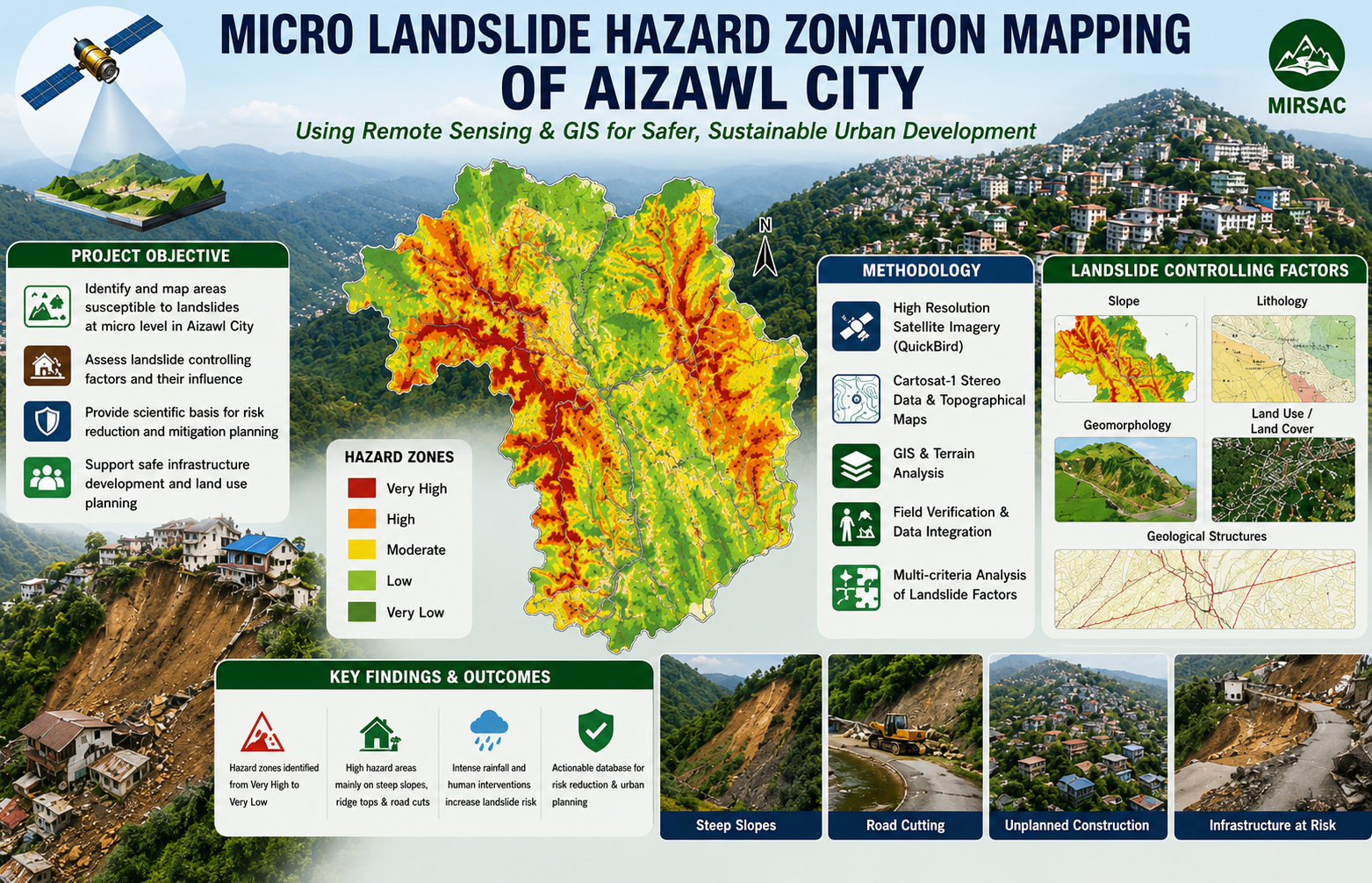
The Micro Landslide Hazard Zonation Mapping of Aizawl City using Remote Sensing and GIS was undertaken by the Mizoram Remote Sensing Application Centre (MRSAC) as an in-house project funded by the Science, Technology and Environment Wing, Planning Department, Government of Mizoram. The study was initiated following consultations with the Disaster Management and Rehabilitation Department in response to recurring landslides, rapid urban expansion and increasing development pressure on the steep and geologically fragile slopes of Aizawl city.
The main objective was to prepare a detailed, micro-level landslide hazard zonation database for the entire Aizawl city area and identify locations with different degrees of potential slope instability. High-resolution QuickBird satellite imagery, Cartosat-I stereo data, Survey of India topographical maps, published geological information and field observations were integrated using Remote Sensing, Geographic Information System and digital terrain-analysis techniques. The project examined major landslide-controlling parameters, including land use and land cover, slope, geomorphology, lithology and geological structures. These thematic layers were evaluated and combined to divide the city into relative hazard categories and to support the formulation of suitable mitigation measures.
The study is particularly important because Aizawl is developed along narrow ridges and steep hill slopes that are exposed to intense monsoon rainfall, unregulated construction, road cutting, quarrying and alteration of natural drainage. These conditions increase the vulnerability of settlements, roads, public utilities and other infrastructure to slope failures.
The resulting hazard-zonation maps, thematic datasets and project report provide valuable decision-support information for the Disaster Management and Rehabilitation Department, municipal and planning authorities, engineers, infrastructure agencies and researchers. The outputs can guide building regulations, site selection, road and drainage design, slope-stabilization works, emergency preparedness and hazard-sensitive urban development. They also provide an essential baseline for future monitoring, detailed site investigations and periodic updating of landslide-risk information as Aizawl continues to expand.
Summarize Metadata
Mapping Scale: 1:5,000
Satellite data & Year: IRS P5 Cartosat-I & Quickbird (2006)
Study area: Aizawl City
Collaborating/Funding Agency: Science, Technology & Environment Wing, Planning Department, Government of Mizoram
No. of Report(s) published: 1
Project Period: 2007 - 2008
The main objective was to prepare a detailed, micro-level landslide hazard zonation database for the entire Aizawl city area and identify locations with different degrees of potential slope instability. High-resolution QuickBird satellite imagery, Cartosat-I stereo data, Survey of India topographical maps, published geological information and field observations were integrated using Remote Sensing, Geographic Information System and digital terrain-analysis techniques. The project examined major landslide-controlling parameters, including land use and land cover, slope, geomorphology, lithology and geological structures. These thematic layers were evaluated and combined to divide the city into relative hazard categories and to support the formulation of suitable mitigation measures.
The study is particularly important because Aizawl is developed along narrow ridges and steep hill slopes that are exposed to intense monsoon rainfall, unregulated construction, road cutting, quarrying and alteration of natural drainage. These conditions increase the vulnerability of settlements, roads, public utilities and other infrastructure to slope failures.
The resulting hazard-zonation maps, thematic datasets and project report provide valuable decision-support information for the Disaster Management and Rehabilitation Department, municipal and planning authorities, engineers, infrastructure agencies and researchers. The outputs can guide building regulations, site selection, road and drainage design, slope-stabilization works, emergency preparedness and hazard-sensitive urban development. They also provide an essential baseline for future monitoring, detailed site investigations and periodic updating of landslide-risk information as Aizawl continues to expand.
Summarize Metadata
Mapping Scale: 1:5,000
Satellite data & Year: IRS P5 Cartosat-I & Quickbird (2006)
Study area: Aizawl City
Collaborating/Funding Agency: Science, Technology & Environment Wing, Planning Department, Government of Mizoram
No. of Report(s) published: 1
Project Period: 2007 - 2008
Related Publications
1