Project Information
| Code | MIRSAC-PRJ-31 |
|---|---|
| Category | Forestry & Environment |
| Time Period | June 2010 |
| Funding Agency | Environment & Forest Department, Government of Mizoram |
Forest Working Plan Inputs for Mizoram
Forestry
Forest Boundary
Notified Reserve Forests
Forest Administration
Forest Division
Environment & Forest
Working Plan
Project Description
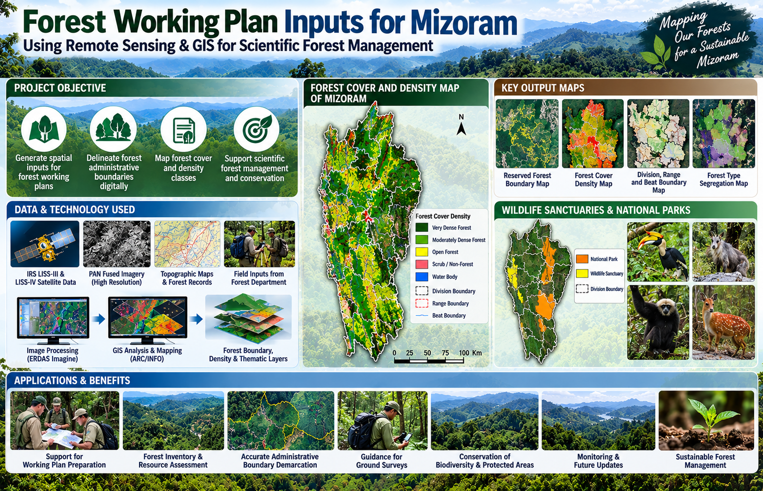
The “Forest Working Plan Inputs for Mizoram” project was initiated in June 2010 as a collaborative geospatial programme involving the Mizoram Remote Sensing Application Centre (MIRSAC), the North Eastern Space Applications Centre (NESAC) and the Environment & Forest Department, Government of Mizoram. Funded by the Forest Department, the project was conceived to strengthen the scientific and spatial information base required for preparation and updating of forest working plans across the State. Its central objective was to translate conventional forest administrative records and field-based knowledge into a standardized digital geospatial framework that could support more accurate forest management, inventory, monitoring and planning.
The project adopted satellite Remote Sensing, digital cartography and GIS-based spatial analysis as its principal technologies. Multi-resolution satellite datasets, including IRS LISS-III, LISS-IV and PAN-fused imagery, were used to map forest cover, delineate administrative units and generate spatial information at appropriate working-plan scales. A major component involved the digital demarcation and verification of forest administrative boundaries, including notified Reserved Forests, Forest Divisions, Ranges and Beats, along with protected areas such as Wildlife Sanctuaries and National Parks. Forest cover was further interpreted into different density classes, which subsequently provided important inputs for growing-stock estimation, forest-type segregation and other working-plan assessments.
The project was implemented phase-wise across all 13 Forest Divisions of Mizoram. Forest Department Working Plan Officers and field personnel played an important role during preparation of base layers, interpretation of legacy records and identification of critical ground-reference information. Their operational knowledge was integrated with satellite imagery and GIS datasets, helping reconcile field-level administrative information with digitally mapped forest boundaries and resource layers. This collaborative approach was particularly important in Mizoram’s rugged terrain, where conventional ground-based forest surveys can be time-consuming and logistically difficult.
By its completion at the end of 2012, the project had generated a substantial collection of working-plan maps, forest administrative boundary datasets, forest-cover and density information, thematic layers and GIS databases, all of which were handed over to the Environment & Forest Department. These outputs provide a valuable reference for working-plan preparation, ground surveys, forest inventory, resource assessment, protected-area management, boundary verification, forest monitoring and future geospatial updating. The project also established a digital baseline that can be progressively integrated with newer satellite, GPS, UAV and field-inventory data, making it an important foundation for long-term scientific forest management in Mizoram.
Summarize Metadata
Mapping Scale: 1:50,000
Satellite data & Year: IRS LISS III & IV, PAN (2009-2010)
Study area: Mizoram
Collaborating/Funding Agency: Environment & Forest Department, Government of Mizoram
No. of Report(s) published: - No Report but Multiple maps & Forest related GIS data generated
Project Period: 2010 - 2012
The project adopted satellite Remote Sensing, digital cartography and GIS-based spatial analysis as its principal technologies. Multi-resolution satellite datasets, including IRS LISS-III, LISS-IV and PAN-fused imagery, were used to map forest cover, delineate administrative units and generate spatial information at appropriate working-plan scales. A major component involved the digital demarcation and verification of forest administrative boundaries, including notified Reserved Forests, Forest Divisions, Ranges and Beats, along with protected areas such as Wildlife Sanctuaries and National Parks. Forest cover was further interpreted into different density classes, which subsequently provided important inputs for growing-stock estimation, forest-type segregation and other working-plan assessments.
The project was implemented phase-wise across all 13 Forest Divisions of Mizoram. Forest Department Working Plan Officers and field personnel played an important role during preparation of base layers, interpretation of legacy records and identification of critical ground-reference information. Their operational knowledge was integrated with satellite imagery and GIS datasets, helping reconcile field-level administrative information with digitally mapped forest boundaries and resource layers. This collaborative approach was particularly important in Mizoram’s rugged terrain, where conventional ground-based forest surveys can be time-consuming and logistically difficult.
By its completion at the end of 2012, the project had generated a substantial collection of working-plan maps, forest administrative boundary datasets, forest-cover and density information, thematic layers and GIS databases, all of which were handed over to the Environment & Forest Department. These outputs provide a valuable reference for working-plan preparation, ground surveys, forest inventory, resource assessment, protected-area management, boundary verification, forest monitoring and future geospatial updating. The project also established a digital baseline that can be progressively integrated with newer satellite, GPS, UAV and field-inventory data, making it an important foundation for long-term scientific forest management in Mizoram.
Summarize Metadata
Mapping Scale: 1:50,000
Satellite data & Year: IRS LISS III & IV, PAN (2009-2010)
Study area: Mizoram
Collaborating/Funding Agency: Environment & Forest Department, Government of Mizoram
No. of Report(s) published: - No Report but Multiple maps & Forest related GIS data generated
Project Period: 2010 - 2012
Related Publications
0
No publications linked to this project yet.