Project Information
| Code | MIRSAC-PRJ-5 |
|---|---|
| Category | Agriculture & Allied |
| Time Period | March 2002 |
| Funding Agency | Ministry of Agriculture, Government of India |
Identification and prioritization of suitable sites for passion fruit using Remote Sensing and GIS technique in Aizawl district, Mizoram state
Horticulture
Site suitability
Aizawl district
Passion fruit
Champhai
Kolasib
Project Description
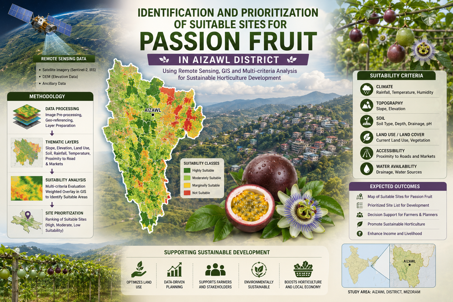
The Identification and Prioritization of Suitable Sites for Passion Fruit using Remote Sensing and GIS Techniques in Aizawl District, Mizoram State was a pilot project under the Technology Mission on the Integrated Development of Horticulture in North Eastern States (including Sikkim), funded by the Ministry of Agriculture, Government of India, and completed in March 2003. It involved key collaboration among Space Applications Centre (SAC)-ISRO, Ahmedabad; Mizoram State Remote Sensing Centre (MSRSC), Aizawl; and Mizoram State Department of Horticulture, Aizawl, pooling expertise in agro-ecology, geospatial analysis, and local horticulture extension.
The project harnessed IRS LISS-III (23 m) and IRS WIFS (188 m) satellite data, processed via digital classification/visual interpretation. Ancillary inputs included SOI topographical sheets, village/road/drainage/soil maps, Census data, and ground truth. GIS (ArcInfo) integrated terrain parameters such as elevation, slope, aspect were used for enabling jhum delineation, crop suitability indexing, prioritization, and village-level mapping/statistics.
The main objective was to map current jhum (shifting cultivation) areas and prioritize sites within them for passion fruit expansion, transitioning unsustainable slash-and-burn practices to viable horticulture amid jhum's dominance (~6–8% annual area in pilot circles). Aizawl district exemplifies NER's horticulture potential (e.g., mandarin orange/passion fruit/banana dominant), yet faces jhum degradation, low settled cultivation (24.4% culturable), and export needs. The study targets the passionfruit production boost in the horticulture circles, promoting year-round fruiting complementarity for processing/juice markets.
The project outputs include village atlases, suitability maps, terrain databases, statistics which offer transformative geospatial intelligence for city/town planning. They guide land-use zoning in jhum hotspots, incentivize farmer transitions, integrate with Technology Mission schemes (orchard expansion/afforestation), and optimize infrastructure (roads/water to clusters). Planners can leverage for sustainable diversification, reducing erosion/soil loss, boosting rural incomes, ensuring nutritional security, and aligning with eco-friendly settled systems in the fragile hills.
Summarize Metadata
Mapping Scale: 1:50,000
Satellite data & Year: IRS LISS III & WIFS (2002)
Study area: Aizawl district
Collaborating/Funding Agency: Ministry of Agriculture, Government of India
No. of Reports published: 1
Project Period: 2002 – 2003