Access Options
Member Only Content
Please log in to view availability or download this document.
| Published | April 01, 1991 |
|---|---|
| Type | Project Report |
| Thematic Category | Land Resources |
| Project | Studies on Dynamics of Shifting Cultivation using Satellite Remote Sensing Techniques |
Analysis of Shifting Cultivation dynamics using Remote Sensing techniques & Status Report on Flora and Fauna of Tuivawl Catchment, Aizawl District, Mizoram.
Abstract / Description
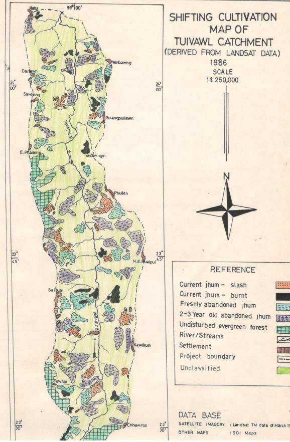
The report authored by Pu Lalnunsiama Colney, MSRSC produced under the in-house initiative “Study of Shifting Cultivation Dynamics using Satellite Remote Sensing Techniques”, presents a focused, catchment-scale assessment of shifting cultivation (jhum) practices in the Tuivawl catchment of Aizawl District, Mizoram, with the explicit aim of jhum dynamics in Tuivawl catchment area using Landsat TM satellite data. The study concentrates on the cyclical land-use processes that define shifting cultivation - clearing, cultivation, abandonment and fallow regeneration - and evaluates how these phases are represented in multi-temporal remotely sensed imagery when interpreted with geospatial techniques and supported by local knowledge.
Satellite imagery constitutes the principal data input. Imagery was processed and analysed using GIS workflows to delineate land-cover classes relevant to jhum dynamics (active cultivation, recent clearings, fallow stages, regenerating vegetation and relatively stable forest). The methodology adopted in the study includes visual interpretation of satellite imagery (Landsat TM) from 1986 and 1989, focusing on color tones to identify cultivation stages. The area affected by jhum cultivation was approximately 11,860 hectares (13.58%) in 1986 and 12,620 hectares (14.46%) in 1989. Current jhum areas were identified as 2,480 hectares in 1986 and 2,620 hectares in 1989. Freshly abandoned jhum areas were 2,540 hectares in 1986 and 2,740 hectares in 1989. The study highlights the ecological impacts of shifting cultivation and the need for sustainable alternatives. Multi-temporal comparison of images enabled the identification of land-use transitions and the estimation of temporal patterns consistent with fallow-cycle behavior. Ancillary spatial data and field observations were used to refine thematic assignments and to resolve mixed or ambiguous signatures that commonly arise in smallholder, mosaic landscapes and steep slopes. The methodological emphasis is on establishing repeatable, institutionally adoptable procedures for mapping jhum at catchment scale rather than producing a single, one-off inventory.
A notable component of the report is an ecological status note describing local flora and fauna within the Tuivawl catchment. The report lists various species of animals, birds, and reptiles found in the Tuivawl catchment, emphasizing the need for conservation efforts. This section contextualizes remote observations by linking landscape-scale changes with on-the-ground biological conditions, thereby strengthening the ecological interpretability of remotely sensed change signals. By integrating species-level and habitat information with mapped land-cover transitions, the study offers a more comprehensive picture of how shifting cultivation interacts with biodiversity and habitat condition at catchment scale.
Overall, the analysis demonstrates that remotely sensed multi-temporal analysis, when combined with local knowledge and targeted field checks, can produce operationally useful information on shifting cultivation dynamics at catchment scale. The study serves as both a methodological test case and a baseline spatial record for the Tuivawl catchment.
Summarized Metadata
Mapping Scale: 1:250,000
Satellite data & Year: Landsat TM, 1986 & 1989
Thematic sub-category: Shifting Cultivation, Watershed
Collaborating/Funding Agency: Mizoram State Remote Sensing Application Centre (MSRSC)
Report Publication Month/Year: April, 1991