Project Information
| Code | MIRSAC-PRJ-2 |
|---|---|
| Category | Forestry & Environment |
| Time Period | April 1991 |
| Funding Agency | Mizoram State Remote Sensing Application Centre (MSRSC) |
Studies on Dynamics of Shifting Cultivation using Satellite Remote Sensing Techniques
Shifting cultivation
Forests
Flora
Fauna
Natural resources
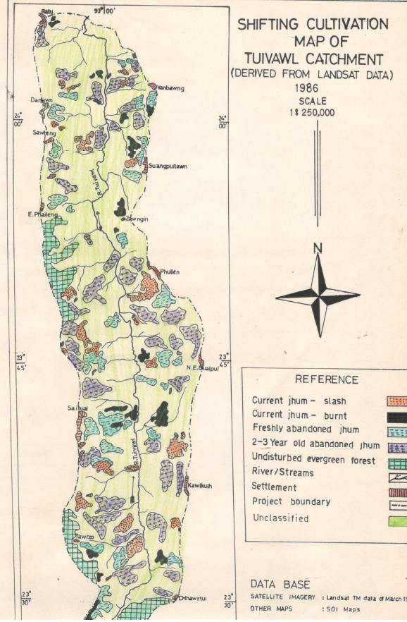
Tuivawl catchment
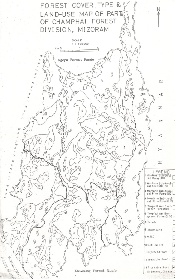
Champhai Forest Division
LULC
Project Description
The project constitutes a two part in-house investigation by the Mizoram Remote Sensing & Space Application Centre (MSRSC) designed to evaluate the capability of remote sensing to detect, quantify and characterize shifting cultivation (jhum) dynamics in Mizoram. The combined work brings together two complementary studies by two in-house scientists, each addressing distinct objectives and study areas while sharing a common methodological framework and institutional purpose. One report specifically addresses the Tuivawl catchment in Aizawl District, and the companion report examines shifting-cultivation dynamics in a separate study area described in the document. Together they form an integrated assessment of jhum patterns and associated ecological responses across representative terrain in the state.
The combined aim of the project is to establish whether multi-temporal satellite data, interpreted with GIS techniques and supported by field observations, can provide a reliable, repeatable basis for mapping land-use transitions associated with shifting cultivation, estimating fallow-cycle durations, and identifying hotspots of forest conversion or regeneration. To this end the two reports unite remote sensing change detection and classification approaches with ground-level ecological reporting (including a status note on flora and fauna for the Tuivawl catchment), thereby linking landscape-level land-cover dynamics with on-the-ground environmental status. This arrangement allows the project to address both the technical performance of remote sensing methods and their ecological validity when applied to Mizoram’s complex, hilly landscape.
Methodologically, the studies use satellite imagery as the principal input, applying temporal comparison and thematic classification to delineate cropping/fallow sequences, shifting cultivation patches, and associated vegetation responses. The Tuivawl component additionally presents a status account of local flora and fauna to contextualise observed land-cover changes. Map products, area statistics and GIS-ready datasets are generated to summarise spatial patterns and trends. Field knowledge and institutional expertise are used to refine thematic assignments and to interpret ambiguous or mixed land-use pixels which is an important consideration in steep, mosaicked landscapes where smallholder practices create heterogeneous signatures.
Collectively, the two studies complied in separate reports deliver: (a) district- and catchment-scale LULC maps focused on jhum cycles and their temporal evolution; (b) quantified area changes and fallow-cycle indicators useful for monitoring; (c) an ecological status synopsis (Tuivawl) that grounds remote observations in species-level and habitat information; and (d) an assessment of remote sensing’s strengths and limitations for operational monitoring of shifting cultivation in Mizoram. The work thus supplies policy-relevant evidence for land-use planners, forest managers, and local development agencies seeking spatially explicit data to inform interventions that aim to balance livelihood practices with conservation and land-use sustainability.
The reports are presented as an internal study to test method feasibility and to provide baseline products for subsequent, more extensive monitoring programmes. Technical specifics such as sensors and temporal span of imagery, mapping scale, classification schema, field-validation protocols, exact study-area boundaries, authorship of the reports, and year(s) of execution and publication are documented within the individual reports and should be referred to for operational or citation purposes.
Summarize Metadata
Mapping Scale: 1:250,000
Satellite data & Year: Landsat TM
Major Land Use / Land Cover categories: Shifting cultivation & Forest types.
Collaborating/Funding Agency: Mizoram State Remote Sensing Application Centre (MSRSC)
No. of Reports published: 2
Project Period: 1991 - 1993