Access Options
Member Only Content
Please log in to view availability or download this document.
| Published | April 06, 1993 |
|---|---|
| Type | Project Report |
| Thematic Category | Land Resources |
| Project | Studies on Dynamics of Shifting Cultivation using Satellite Remote Sensing Techniques |
Studies on dynamics of Shifting Cultivation and its influence on forest ecosystem by Satellite Remote Sensing techniques
Abstract / Description
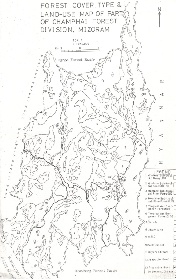
The project report authored by Dr.R.K.Lallianthanga, MSRSC investigates the spatial and temporal dynamics of shifting cultivation (jhum) and its ecological influence on forest ecosystems, with the dual aim of (1) testing the capability of satellite remote sensing and GIS to detect and quantify jhum cycles in the study area, and (2) linking remotely-sensed land-cover change with on-the-ground ecological indicators (vegetation structure, species composition and biomass/productivity). Initiated as an in-house study at MSRSC, the work combines multi-temporal satellite imagery, image classification and change-detection techniques with stratified field sampling (phytosociological surveys, biomass estimation and fallow-age stratification) to establish an integrated picture of how jhum practices alter landscape structure and ecological condition of forests over time. The project area covers part of Champhai Forest division. The study area was selected so as to exclude bamboo forests and confine studies in Montane sub-tropical forests and Tropical Wet Evergreen forests.
Methodology employed multi-temporal Landsat TM image analysis to delineate land-cover classes relevant to jhum dynamics (active cultivation, recent clearings, multiple fallow classes, regenerating vegetation and closed forest). Imagery interpretation and GIS processing were used to map patch boundaries, compute area statistics, and produce time-series maps showing transitions between classes. The remote sensing analyses were calibrated and validated using field observations: plots stratified by fallow age were sampled for species composition, stem density, and aboveground biomass; these in-situ measurements were used to interpret remotely sensed signatures and to assess recovery trajectories across different fallow durations. The report documents the classification approach, sampling design, and the protocols used for biomass and productivity estimation.
Principal outcomes demonstrate that multi-temporal satellite data, when combined with targeted field validation, can reliably identify shifting cultivation patches and distinguish fallow classes in Mizoram’s complex terrain. The study produced thematic LULC maps showing the spatial distribution of active jhum, recent clearings and regenerating fallows, together with GIS-ready datasets and area statistics for each mapped class. Field-based phytosociological results indicate progressive recovery of vegetation complexity and biomass with increasing fallow age; species composition shifts from early-successional herbs and shrubs in newly abandoned sites to progressively woody and structurally complex stands in longer fallows, consistent with measured increases in aboveground biomass and stem density. The report also outlines observed relationships between fallow age and key ecological metrics (documented in tabular form), and discusses implications for carbon stock recovery, soil conservation and biodiversity conservation in jhum mosaics.
The study highlights both the strengths and limitations of the applied approach. Remote sensing provides robust spatial coverage and repeatability for monitoring jhum at landscape scale, but classification accuracy is constrained by small patch size, steep slopes and mixed land-use signals. Such inherent issues alleviated by higher temporal resolution imagery and systematic field calibration. The report concludes with practical recommendations for operational monitoring (preferred temporal resolution, field-validation density, and fallow-age stratification), and positions the products as baseline datasets for planners and forest managers engaged in sustainable land-use interventions.
Summarized Metadata
Mapping Scale: 1:250,000
Satellite data & Year: Landsat TM, Multi-temporal prior to 1993
Thematic sub-category: Forest, Shifting Cultivation
Collaborating/Funding Agency: Mizoram State Remote Sensing Application Centre (MSRSC)
Report Publication Month/Year: April, 1993