Mapping of Agriculture/Horticulture Potential areas within R.Tut Riverine Reserve Forest, Mamit District using Remote Sensing and GIS
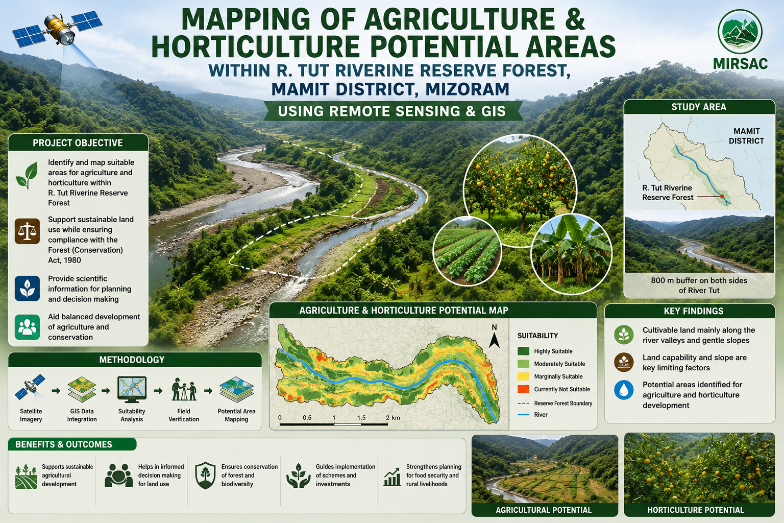
The project “Mapping of Agriculture and Horticulture Potential Areas within R. Tut Riverine Reserve Forest, Mamit District, Mizoram using Remote Sensing and GIS” was undertaken by the Mizoram Remote Sensing Application Centre (MRSAC) under the Science & Technology, Planning Department, Government of Mizoram, with sponsorship from the Environment and Forest Department, Government of Mizoram. The study was initiated following consultations with forest authorities to identify cultivable land within the legally protected riverine reserve while ensuring that any proposed diversion or utilization complies with the provisions of the Forest (Conservation) Act, 1980. The study area covers the River Tut Riverine Reserve Forest in Mamit District, extending approximately 800 metres on both sides of the river. Mizoram’s rugged terrain offers limited scope for large-scale agriculture, making the low-lying valleys and riverbank areas especially important for crop development. The main objective was therefore to identify and spatially delineate land suitable for agriculture and horticulture and provide a scientific basis for evaluating future land-use proposals. The project integrated satellite remote sensing, GIS analysis, Survey of India topographic maps, collateral information and field verification. Thematic datasets on land use and land cover, slope and land capability were generated and overlaid to identify potentially suitable areas. Inputs and field-level guidance were provided by the Environment and Forest Department, Mamit Forest Division and the district Agriculture authorities. The resulting maps, sector-wise spatial database and accompanying report provide an important planning resource for forest administrators, agriculture and horticulture departments, district authorities and development agencies. They can support crop-development planning, land capability assessment, field verification, evaluation of forest-diversion proposals and identification of appropriate compensatory conservation measures. The project demonstrates how Remote Sensing and GIS can help balance agricultural development with forest protection by supplying objective, location-specific information for transparent and environmentally responsible decision-making. Summarize Metadata Mapping Scale: 1:50,000 Satellite data & Year: IRS 1D – LISS III (2006); Cartosat-1 (April & December, 2006) Study area: Tut Riverine Reserve Forest, Mamit district Collaborating/Funding Agency: Environment & Forest Department, Government of Mizoram No. of Report(s) published: 1 Project Period: 2007 - 2008
Mapping of Forest Administrative Boundary of Mizoram
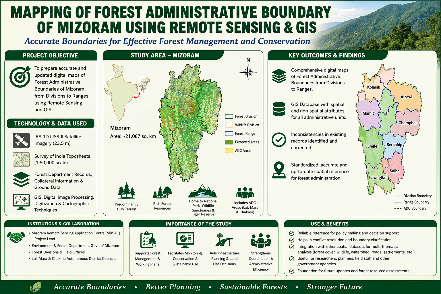
The Mapping of Forest Administrative Boundary of Mizoram using Remote Sensing and GIS was undertaken as an in-house project of the Mizoram Remote Sensing Application Centre (MRSAC) under the Science & Technology, Planning Department, Government of Mizoram, and was included in the Centre's Annual Plan for 2007–08. The project was conceived in recognition of the critical ecological and socio-economic importance of Mizoram's forests and the need for an accurate, standardized, and spatially referenced delineation of the administrative framework responsible for their conservation, management, and sustainable utilization. The primary objective was to prepare comprehensive digital Forest Administrative Boundary maps of Mizoram, covering the hierarchical administrative units of the Forest Department, from Forest Divisions and Wildlife Divisions to Forest Ranges and other relevant administrative units. The project covered the entire State of Mizoram, an area of approximately 21,087 sq. km, characterized by predominantly hilly terrain and extensive forest resources. The mapping also incorporated important protected and conservation areas, including Murlen National Park, Khawnglung, Thorang, Tawi and Lengteng Wildlife Sanctuaries, Zoological Park, Dampa Tiger Reserve, and forest areas administered by the Lai, Mara and Chakma Autonomous District Councils. The project integrated IRS-1D LISS-III satellite imagery with 23.5 m spatial resolution, Survey of India topographic sheets at 1:50,000 scale, departmental records, collateral information, and ground data. Satellite imagery and existing Forest Department records were compared and integrated using Remote Sensing, GIS, digital image processing, digitization, and cartographic techniques. This approach enabled inconsistencies and anomalies in existing boundary information to be identified and corrected, while providing a systematic means of updating and standardizing the spatial representation of forest administrative units. The resulting maps were prepared at appropriate scales for different administrative areas, with important spatial and non-spatial attributes embedded within the digital database. The project involved close coordination with the Environment & Forest Department, Government of Mizoram, whose officers and staff provided preliminary administrative information and departmental records. Inputs were also obtained from the Forest Divisions and staff of the three Autonomous District Councils—Lai Autonomous District Council (LADC), Mara Autonomous District Council (MADC), and Chakma Autonomous District Council (CADC). This institutional collaboration was essential for validating existing administrative information and ensuring that the resulting geospatial products reflected the operational framework of forest administration in the State. The principal outcome was a comprehensive set of illustrated Forest Administrative Boundary maps and a digital GIS database covering the State's forest administrative structure. These outputs provide a reliable spatial reference for the Environment & Forest Department, forest managers, planners, researchers, and other government agencies. The database can support forest resource conservation, monitoring, sustainable utilization, working-plan preparation, field-level administration, infrastructure planning, and area-specific development programmes. It also provides an effective framework for integrating forest administrative boundaries with other geospatial datasets, including forest cover, land use, biodiversity, protected areas, watersheds, roads, settlements, and other natural resource information. Overall, the project demonstrated the value of Remote Sensing and GIS as cost-effective and efficient tools for demarcating, updating, and managing complex administrative boundaries in a forested and mountainous landscape. The resulting maps, digital datasets, and associated report constitute an important baseline reference for systematic forest administration and provide a foundation for improved coordination, monitoring, planning, and sustainable management of Mizoram's valuable forest resources. Summarize Metadata Mapping Scale: 1:50,000 Satellite data & Year: IRS 1D LISS III (2006) Study area: Mizoram Collaborating/Funding Agency: Mizoram Remote Sensing Application Centre No. of Report(s) published: 1 Project Period: 2006 - 2008
Tiger Habitat Analysis in Dampa Tiger Reserve, Mizoram
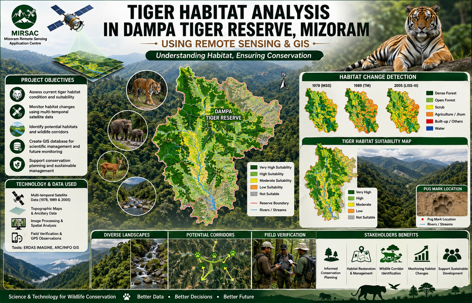
The project “Tiger Habitat Analysis in Dampa Tiger Reserve, Mizoram using Remote Sensing and GIS” was undertaken to evaluate the condition and suitability of tiger habitat within Dampa Tiger Reserve and its surrounding landscape, and to support scientific conservation and management planning through geospatial technologies. The study was carried out in close association with Northeastern Space Application Centre (NESAC) and Environment & Forest Department, Government of Mizoram, which provided reserve boundaries, wildlife census information and other field-level data required for analysis. The main objectives were to prepare an inventory of vegetation types, forest density and water bodies, assess long-term habitat changes, characterize suitable tiger habitat, identify possible habitat and corridor areas outside the reserve, and create a digital database for future management. The project employed a multi-temporal Remote Sensing and GIS approach using Landsat MSS data from 1978, Landsat TM data from 1989, IRS-1D LISS-III and PAN data, and IRS-P6 LISS-III imagery from 2005, supported by topographic information, socio-economic data from surrounding villages and field verification. GIS-based spatial modelling integrated vegetation type, forest density, slope, aspect, elevation, proximity to water and observed tiger pug-mark locations to develop a tiger habitat suitability model and map. The surrounding buffer area was also examined to evaluate habitat continuity and potential corridors beyond the reserve boundary. The importance of the study lies in its ability to link wildlife observations with measurable landscape characteristics and long-term vegetation change. The report identifies degradation and fragmentation of closed evergreen and semi-evergreen forests, largely associated with shifting cultivation and other biotic pressures, as important threats to tiger habitat quality. The resulting habitat suitability maps, vegetation and forest-density datasets, change-analysis outputs and digital GIS database provide valuable baseline information for the Forest Department, wildlife managers, conservation planners and researchers. These outputs can support habitat restoration, monitoring of forest degradation, management of buffer zones, identification of wildlife corridors, prioritization of conservation interventions and periodic assessment of habitat change, thereby strengthening long-term conservation planning for Dampa Tiger Reserve and its surrounding landscape. Summarize Metadata Mapping Scale: 1:50,000 Satellite data & Year: Landsat MSS (1978), Landsat TM (1989), IRS 1D LISS III (1999), IRS 1D PAN (2003), IRS P6 LISS-III (2005). Study area: Dampa Tiger Reserve Collaborating/Funding Agency: North Eastern Space Applications Centre (NESAC) & Environment & Forest Department, Government of Mizoram. No. of Report(s) published: 1 Project Period: 2005 – 2008
Studies on Dynamics of Shifting Cultivation using Satellite Remote Sensing Techniques
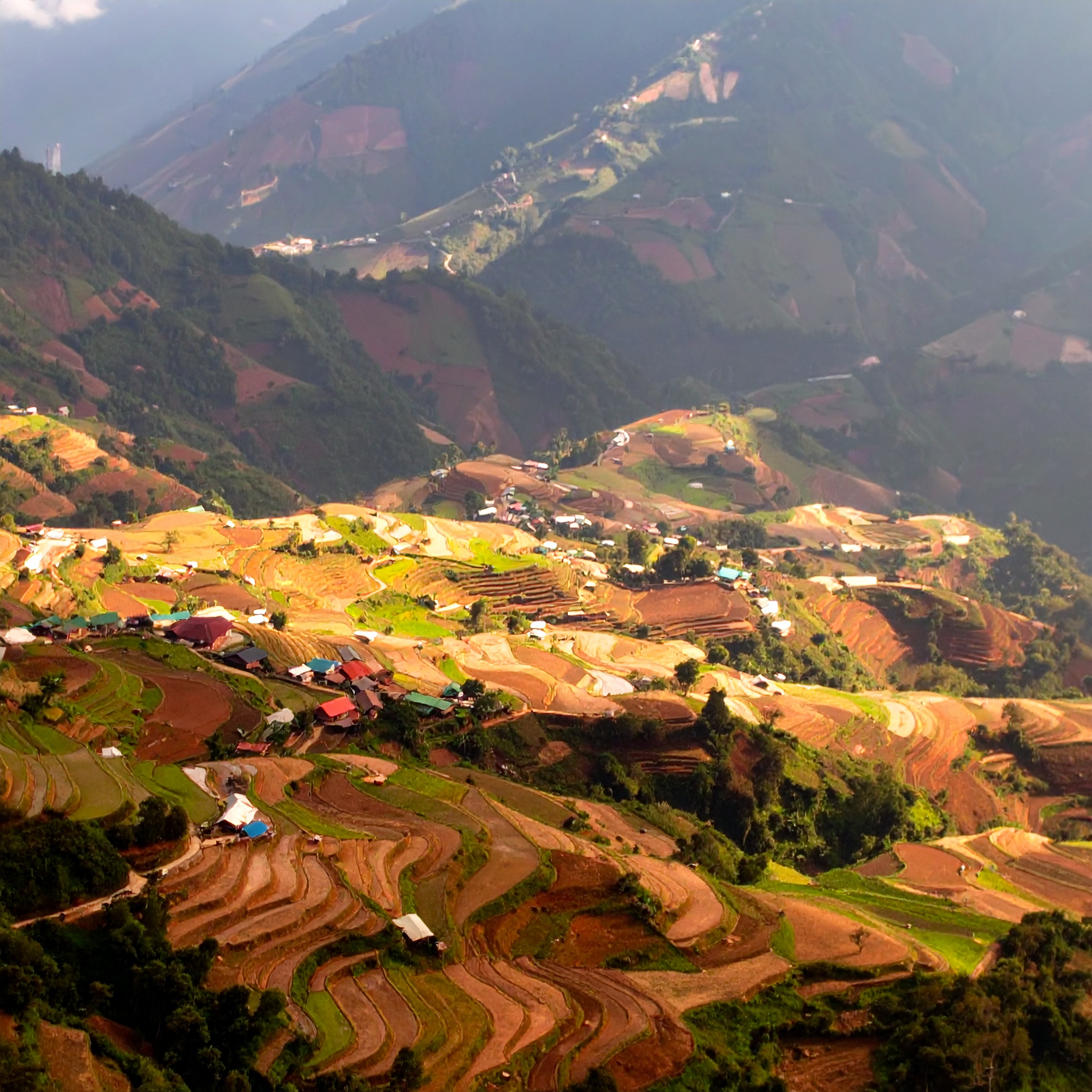
The project constitutes a two part in-house investigation by the Mizoram Remote Sensing & Space Application Centre (MSRSC) designed to evaluate the capability of remote sensing to detect, quantify and characterize shifting cultivation (jhum) dynamics in Mizoram. The combined work brings together two complementary studies by two in-house scientists, each addressing distinct objectives and study areas while sharing a common methodological framework and institutional purpose. One report specifically addresses the Tuivawl catchment in Aizawl District, and the companion report examines shifting-cultivation dynamics in a separate study area described in the document. Together they form an integrated assessment of jhum patterns and associated ecological responses across representative terrain in the state. The combined aim of the project is to establish whether multi-temporal satellite data, interpreted with GIS techniques and supported by field observations, can provide a reliable, repeatable basis for mapping land-use transitions associated with shifting cultivation, estimating fallow-cycle durations, and identifying hotspots of forest conversion or regeneration. To this end the two reports unite remote sensing change detection and classification approaches with ground-level ecological reporting (including a status note on flora and fauna for the Tuivawl catchment), thereby linking landscape-level land-cover dynamics with on-the-ground environmental status. This arrangement allows the project to address both the technical performance of remote sensing methods and their ecological validity when applied to Mizoram’s complex, hilly landscape. Methodologically, the studies use satellite imagery as the principal input, applying temporal comparison and thematic classification to delineate cropping/fallow sequences, shifting cultivation patches, and associated vegetation responses. The Tuivawl component additionally presents a status account of local flora and fauna to contextualise observed land-cover changes. Map products, area statistics and GIS-ready datasets are generated to summarise spatial patterns and trends. Field knowledge and institutional expertise are used to refine thematic assignments and to interpret ambiguous or mixed land-use pixels which is an important consideration in steep, mosaicked landscapes where smallholder practices create heterogeneous signatures. Collectively, the two studies complied in separate reports deliver: (a) district- and catchment-scale LULC maps focused on jhum cycles and their temporal evolution; (b) quantified area changes and fallow-cycle indicators useful for monitoring; (c) an ecological status synopsis (Tuivawl) that grounds remote observations in species-level and habitat information; and (d) an assessment of remote sensing’s strengths and limitations for operational monitoring of shifting cultivation in Mizoram. The work thus supplies policy-relevant evidence for land-use planners, forest managers, and local development agencies seeking spatially explicit data to inform interventions that aim to balance livelihood practices with conservation and land-use sustainability. The reports are presented as an internal study to test method feasibility and to provide baseline products for subsequent, more extensive monitoring programmes. Technical specifics such as sensors and temporal span of imagery, mapping scale, classification schema, field-validation protocols, exact study-area boundaries, authorship of the reports, and year(s) of execution and publication are documented within the individual reports and should be referred to for operational or citation purposes. Summarize Metadata Mapping Scale: 1:250,000 Satellite data & Year: Landsat TM Major Land Use / Land Cover categories: Shifting cultivation & Forest types. Collaborating/Funding Agency: Mizoram State Remote Sensing Application Centre (MSRSC) No. of Reports published: 2 Project Period: 1991 - 1993