Land Use Planning for NLUP Implementation using Remote Sensing & GIS
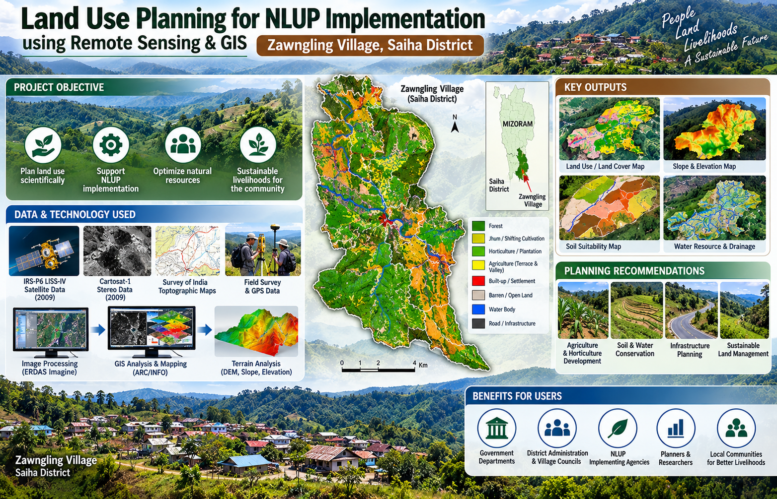
The “Land Use Planning for NLUP Implementation using Remote Sensing and GIS” project was undertaken by the Mizoram Remote Sensing Application Centre (MIRSAC), Science & Technology, Planning Department, Government of Mizoram, as a pilot study for Zawngling Village in Saiha District. The project emerged from coordination with the NLUP Implementing Board, Saiha District administration and Zawngling Village Council, with additional technical support from KVK and the Agriculture Department, Saiha for soil analysis. Its purpose was to demonstrate how scientific land-use planning could strengthen implementation of Mizoram’s New Land Use Policy (NLUP) at village level. The project combined Remote Sensing, GIS, GPS-supported field verification and socio-economic information to prepare an integrated spatial database of village resources. High-resolution IRS-P6 LISS-IV and Cartosat-1 stereo satellite data acquired in 2009 were used along with Survey of India topographic maps, departmental records and field observations. Image processing was carried out in ERDAS Imagine, while GIS analysis and database integration were undertaken using ARC/INFO. Cartosat stereo data also supported preparation of terrain information such as slope and Digital Elevation Models. The principal objective was to develop a practical methodology for integrating land use/land cover, soils, slope, altitude, drainage, water resources, infrastructure and socio-economic information to identify suitable areas for different NLUP activities and formulate realistic land- and water-resource development plans. Zawngling was selected because of its diverse natural-resource setting, rugged terrain and predominantly agriculture-based rural economy. The resulting thematic maps, GIS database and action-planning outputs provide useful decision support for NLUP implementing agencies, district authorities, village councils, agriculture and horticulture departments, planners and researchers. Importantly, the pilot established a replicable framework for extending scientifically based, participatory and resource-compatible land-use planning to other villages of Mizoram. Summarize Metadata Mapping Scale: 1:5000 Satellite data & Year: IRS P6 LISS IV (2009) & Cartosat-I (2009) Study area: Zawngling village, Saiha district Collaborating/Funding Agency: NIB (NLUP Implementing Board) No. of Report(s) published: 1 Project Period: 2010
Forest Working Plan Inputs for Mizoram
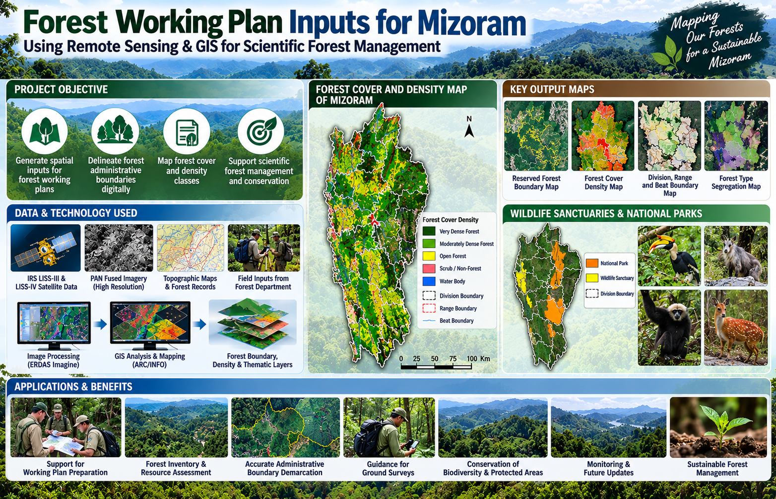
The “Forest Working Plan Inputs for Mizoram” project was initiated in June 2010 as a collaborative geospatial programme involving the Mizoram Remote Sensing Application Centre (MIRSAC), the North Eastern Space Applications Centre (NESAC) and the Environment & Forest Department, Government of Mizoram. Funded by the Forest Department, the project was conceived to strengthen the scientific and spatial information base required for preparation and updating of forest working plans across the State. Its central objective was to translate conventional forest administrative records and field-based knowledge into a standardized digital geospatial framework that could support more accurate forest management, inventory, monitoring and planning. The project adopted satellite Remote Sensing, digital cartography and GIS-based spatial analysis as its principal technologies. Multi-resolution satellite datasets, including IRS LISS-III, LISS-IV and PAN-fused imagery, were used to map forest cover, delineate administrative units and generate spatial information at appropriate working-plan scales. A major component involved the digital demarcation and verification of forest administrative boundaries, including notified Reserved Forests, Forest Divisions, Ranges and Beats, along with protected areas such as Wildlife Sanctuaries and National Parks. Forest cover was further interpreted into different density classes, which subsequently provided important inputs for growing-stock estimation, forest-type segregation and other working-plan assessments. The project was implemented phase-wise across all 13 Forest Divisions of Mizoram. Forest Department Working Plan Officers and field personnel played an important role during preparation of base layers, interpretation of legacy records and identification of critical ground-reference information. Their operational knowledge was integrated with satellite imagery and GIS datasets, helping reconcile field-level administrative information with digitally mapped forest boundaries and resource layers. This collaborative approach was particularly important in Mizoram’s rugged terrain, where conventional ground-based forest surveys can be time-consuming and logistically difficult. By its completion at the end of 2012, the project had generated a substantial collection of working-plan maps, forest administrative boundary datasets, forest-cover and density information, thematic layers and GIS databases, all of which were handed over to the Environment & Forest Department. These outputs provide a valuable reference for working-plan preparation, ground surveys, forest inventory, resource assessment, protected-area management, boundary verification, forest monitoring and future geospatial updating. The project also established a digital baseline that can be progressively integrated with newer satellite, GPS, UAV and field-inventory data, making it an important foundation for long-term scientific forest management in Mizoram. Summarize Metadata Mapping Scale: 1:50,000 Satellite data & Year: IRS LISS III & IV, PAN (2009-2010) Study area: Mizoram Collaborating/Funding Agency: Environment & Forest Department, Government of Mizoram No. of Report(s) published: - No Report but Multiple maps & Forest related GIS data generated Project Period: 2010 - 2012
Integrated Land Use Planning
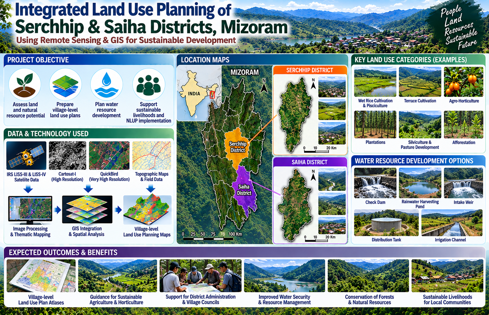
The Integrated Land Use Planning (ILUP) Project was undertaken by the Mizoram Remote Sensing Application Centre (MIRSAC), Science & Technology, Planning Department, Government of Mizoram, to develop scientifically based land-use plans for Serchhip and Saiha districts. The project was conceived in support of sustainable rural development and initiatives such as the New Land Use Policy (NLUP), where appropriate utilization of land and natural resources required reliable spatial information at district and village levels. The project was financially supported by the Science, Technology & Environment Wing, Planning Department, with active cooperation from the District Administration, concerned Government departments and Village Councils during data collection and field verification. The project extensively employed Remote Sensing and Geographic Information System (GIS) technologies using multi-resolution satellite datasets including IRS LISS-III, LISS-IV, Cartosat-I and QuickBird imagery. These datasets were integrated with information on existing land use, terrain and slope, soils, rainfall, surface and groundwater resources, transport networks and other natural-resource parameters to formulate spatially explicit land-use recommendations. A major strength of the project was its village-level planning approach. The resulting atlases provided individual maps depicting settlements, transport networks and drainage systems alongside corresponding Integrated Land Use Planning maps. Proposed interventions included areas suitable for wet rice cultivation and pisciculture, terrace cultivation, agro-horticulture, plantations, silviculture, pasture development and afforestation, together with water-resource structures such as check dams, rainwater-harvesting ponds, intake weirs and irrigation systems. The generated maps, atlases and GIS databases provide valuable decision-support information for Government departments, district administrations, Village Councils, planners, researchers and development agencies, helping them identify resource-compatible interventions, plan field programmes, prioritize investments and promote sustainable land and water-resource management across the two districts. Summarize Metadata Mapping Scale: 1:10,000 Satellite data & Year: IRS P6 LISS III, LISS IV, Cartosat I & Quickbird (2009-2010) Study area: Serchhip & Saiha Districts Collaborating/Funding Agency: Science & Technology, Planning Department, Government of Mizoram No. of Report(s) published: 2 Atlases Project Period: 2010-2011
Groundwater Potential Zonation & Surface Water Inventory Mapping of Mizoram
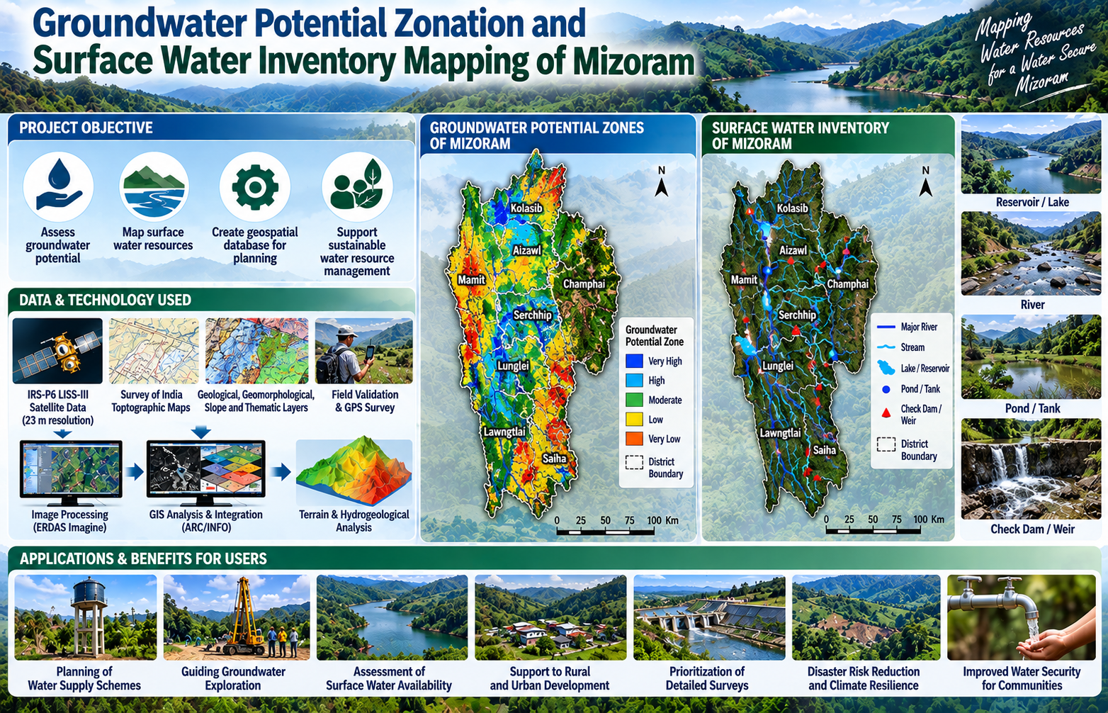
The “Groundwater Potential Zonation and Surface Water Inventory Mapping of Mizoram” project was undertaken by the Mizoram Remote Sensing Application Centre (MIRSAC), Science & Technology, Planning Department, Government of Mizoram, with funding support from the Public Health Engineering Department (PHED), Government of Mizoram. The study was conceived to provide a scientific, State-wide assessment of groundwater prospects and surface-water resources in response to the growing demand for reliable water supply arising from population growth, urbanization and development. The project covered the entire State of Mizoram and applied Remote Sensing and Geographic Information System (GIS) techniques to integrate hydrogeological and terrain-related information. IRS-P6 LISS-III satellite imagery with 23 m spatial resolution was used together with Survey of India topographic maps, geological and geomorphological information, slope data, administrative boundaries and field-based ground verification. GIS-based integration of lithology, geomorphology, geological structures, slope and available groundwater indicators was used to delineate groundwater potential zones, while surface-water bodies such as rivers, streams, lakes, ponds and reservoirs were mapped directly from satellite imagery. The main objective was to prepare a comprehensive spatial database and maps showing areas of varying groundwater potential together with an inventory of important surface-water resources. Such information is particularly important in Mizoram because its rugged terrain, complex geology and strongly dissected drainage system make conventional water-resource assessment and infrastructure planning challenging. The resulting district-wise and State-level maps and databases provide valuable decision-support information for PHED, district administrations, planners, engineers, researchers and other development departments. They can assist in preliminary identification of areas suitable for groundwater exploration, planning of water-supply schemes, assessment of surface-water availability, prioritization of detailed hydrogeological and geophysical surveys, and long-term water-resource management. The project therefore provides an important geospatial baseline for improving water-security planning and sustainable utilization of Mizoram’s groundwater and surface-water resources. Summarize Metadata Mapping Scale: 1:50,000 Satellite data & Year: IRS P6 LISS IV (2009) Study area: Mizoram Collaborating/Funding Agency: PHED, Government of Mizoram No. of Report(s) published: 1 Project Period: 2010
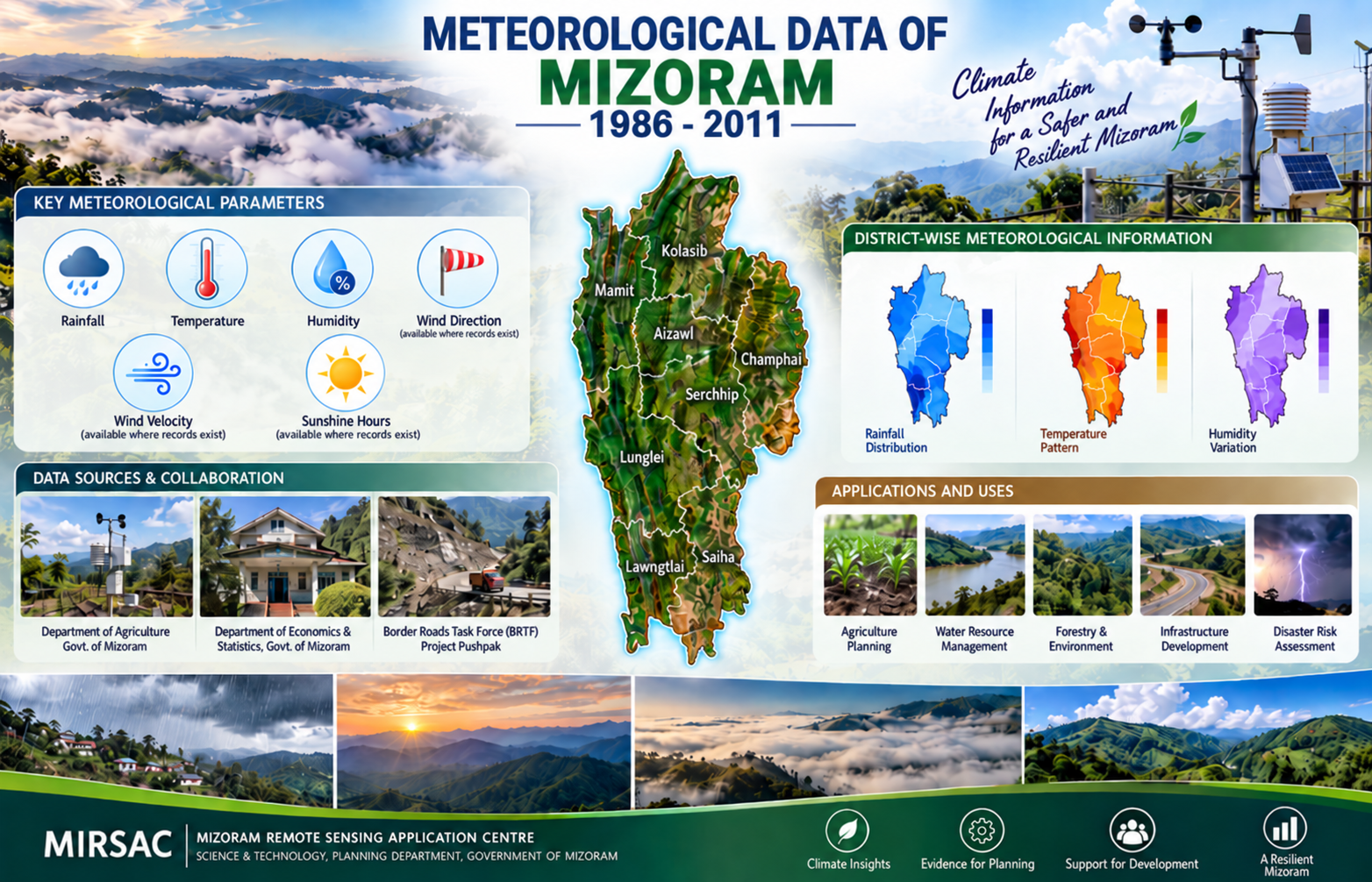
Meteorological Data of Mizoram
The Meteorological Data of Mizoram project was undertaken as an in-house initiative of the Mizoram Remote Sensing Application Centre (MIRSAC), Science & Technology, Planning Department, Government of Mizoram, to develop an organized and readily accessible meteorological database for scientific, developmental and geospatial applications across the State. The initiative arose from the recurring requirement for reliable climatic inputs in Remote Sensing, GIS, natural-resource assessment and other planning-oriented studies undertaken by MIRSAC and various user departments. The project was implemented in two phases. The first phase compiled available weather observations covering 1986–2008, culminating in the publication of the first meteorological data report in 2009. The second phase subsequently extended and updated the database to include available observations covering 1986–2011, thereby improving the temporal continuity and usefulness of the climatic information resource. Meteorological records were compiled through institutional cooperation with agencies maintaining weather observations in Mizoram, particularly the Department of Agriculture, Government of Mizoram; Department of Economics & Statistics, Government of Mizoram; and Border Roads Task Force (BRTF), Project Pushpak. The principal parameters assembled included rainfall, temperature and humidity, with the information organized district-wise and at the State level wherever records were available. The resulting reports serve as a valuable ready-reference climatic database for government departments, researchers, planners, students and technical agencies. They provide essential baseline information for agriculture and horticulture planning, water-resource assessment, forestry, environmental studies, disaster-risk analysis, infrastructure planning and Remote Sensing/GIS modelling. By progressively consolidating historical observations through successive phases, the project also provides an important foundation for long-term climate monitoring, temporal comparison, future database updating and evidence-based developmental planning in Mizoram. Summarize Metadata Mapping Scale: N.A Satellite data & Year: NA Study area: Mizoram Collaborating/Funding Agency: Mizoram Remote Sensing Application Centre (MIRSAC) No. of Report(s) published: 2 Project Period: 2009 & 2012