Micro Landslide Hazard Zonation Mapping of Aizawl City
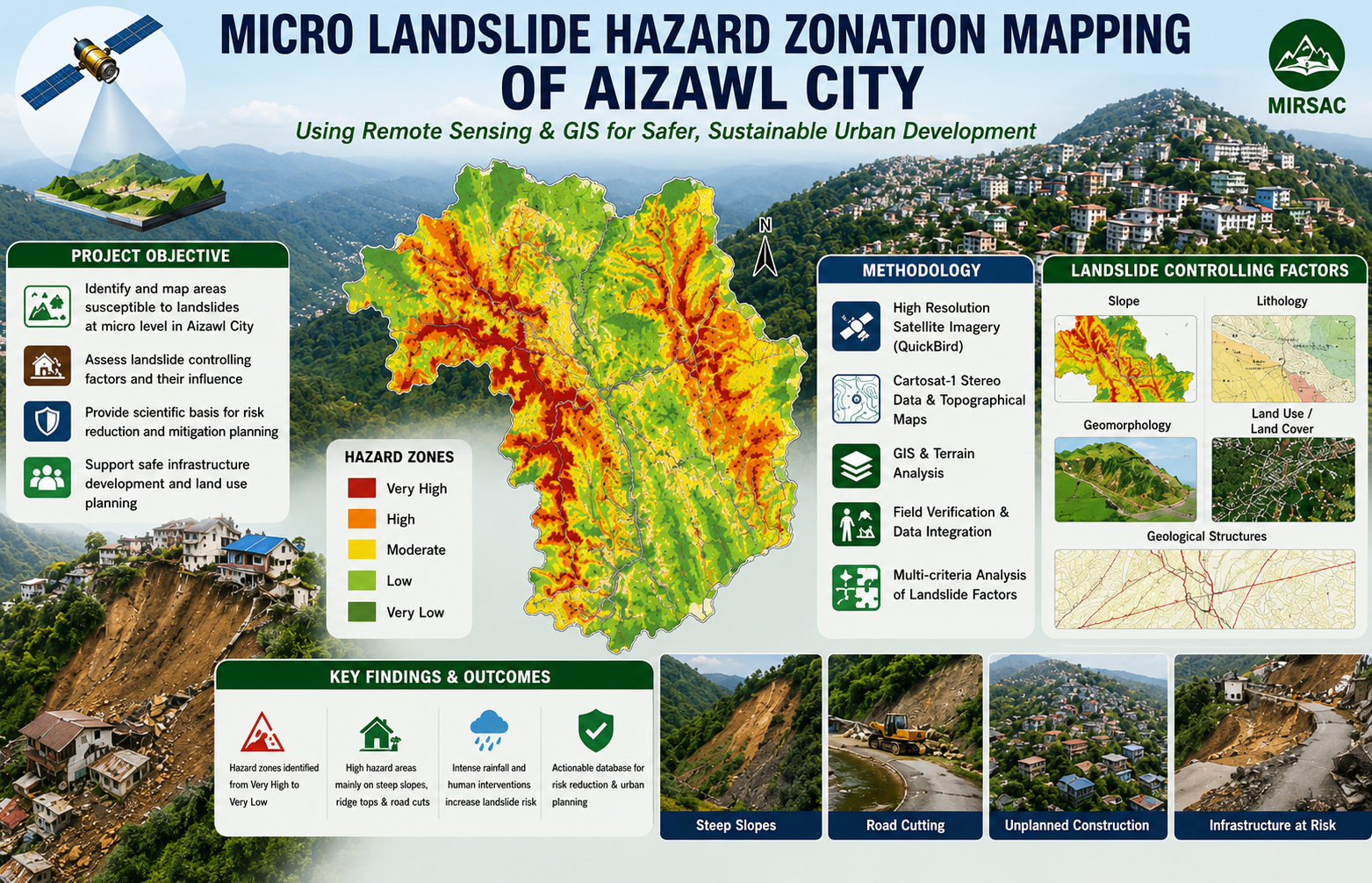
The Micro Landslide Hazard Zonation Mapping of Aizawl City using Remote Sensing and GIS was undertaken by the Mizoram Remote Sensing Application Centre (MRSAC) as an in-house project funded by the Science, Technology and Environment Wing, Planning Department, Government of Mizoram. The study was initiated following consultations with the Disaster Management and Rehabilitation Department in response to recurring landslides, rapid urban expansion and increasing development pressure on the steep and geologically fragile slopes of Aizawl city. The main objective was to prepare a detailed, micro-level landslide hazard zonation database for the entire Aizawl city area and identify locations with different degrees of potential slope instability. High-resolution QuickBird satellite imagery, Cartosat-I stereo data, Survey of India topographical maps, published geological information and field observations were integrated using Remote Sensing, Geographic Information System and digital terrain-analysis techniques. The project examined major landslide-controlling parameters, including land use and land cover, slope, geomorphology, lithology and geological structures. These thematic layers were evaluated and combined to divide the city into relative hazard categories and to support the formulation of suitable mitigation measures. The study is particularly important because Aizawl is developed along narrow ridges and steep hill slopes that are exposed to intense monsoon rainfall, unregulated construction, road cutting, quarrying and alteration of natural drainage. These conditions increase the vulnerability of settlements, roads, public utilities and other infrastructure to slope failures. The resulting hazard-zonation maps, thematic datasets and project report provide valuable decision-support information for the Disaster Management and Rehabilitation Department, municipal and planning authorities, engineers, infrastructure agencies and researchers. The outputs can guide building regulations, site selection, road and drainage design, slope-stabilization works, emergency preparedness and hazard-sensitive urban development. They also provide an essential baseline for future monitoring, detailed site investigations and periodic updating of landslide-risk information as Aizawl continues to expand. Summarize Metadata Mapping Scale: 1:5,000 Satellite data & Year: IRS P5 Cartosat-I & Quickbird (2006) Study area: Aizawl City Collaborating/Funding Agency: Science, Technology & Environment Wing, Planning Department, Government of Mizoram No. of Report(s) published: 1 Project Period: 2007 - 2008
Landslides in Mizoram
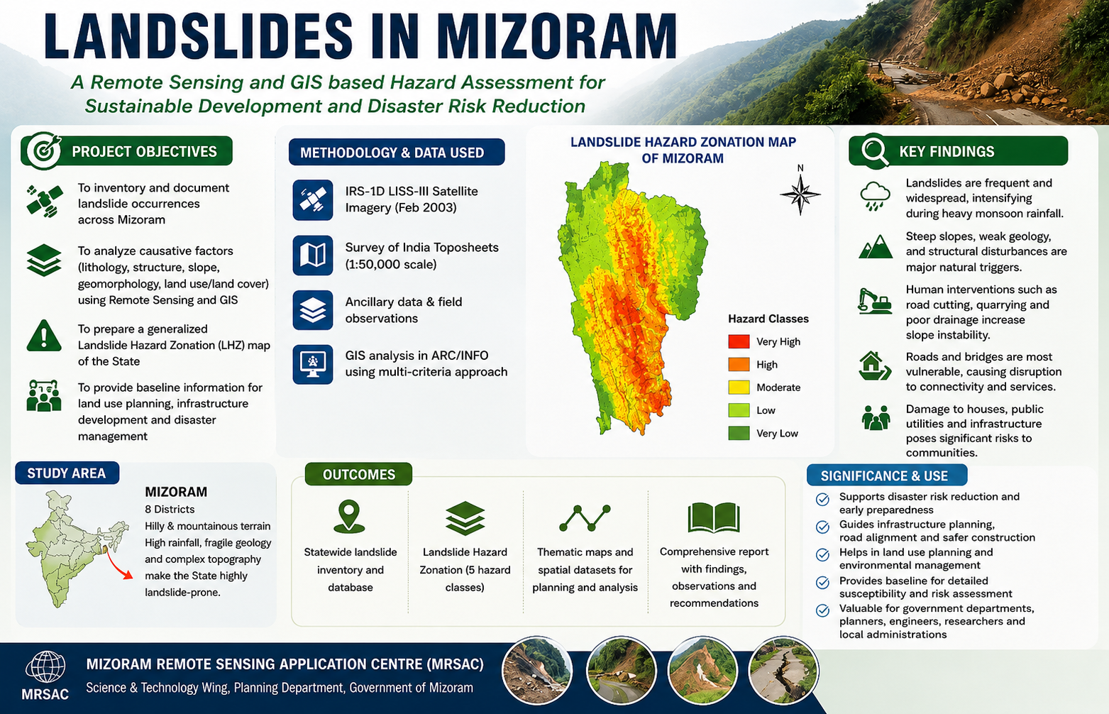
The Report on Landslides in Mizoram, prepared by the Mizoram Remote Sensing Application Centre (MRSAC) under the Science and Technology Wing, Planning Department, Government of Mizoram, was compiled in 2007 in response to the increasing incidence of landslides and associated disruptions across the State's mountainous terrain. The study was undertaken to document recent landslide occurrences, assess their geographical distribution and impacts, and provide an initial scientific understanding of landslide susceptibility across Mizoram, particularly following intense monsoon rainfall during September 2007. The project employed Remote Sensing and Geographic Information System (GIS) techniques to prepare a generalized Landslide Hazard Zonation (LHZ) map for the State. IRS-1D LISS-III satellite imagery acquired in February 2003, together with Survey of India topographic maps at 1:50,000 scale and available ancillary spatial datasets, was used to analyse terrain and geo-environmental conditions. Key causative parameters—including lithology, geological structure, geomorphology, slope, and land use/land cover—were integrated using ARC/INFO GIS software to classify Mizoram into five relative landslide hazard categories. The analysis provided a statewide framework for identifying areas of varying susceptibility and understanding the influence of both natural terrain conditions and human interventions such as road cutting and quarrying. The report also compiled field and administrative information on landslide impacts from across all eight districts of Mizoram, documenting damage to houses, roads, bridges, public utilities, and communication networks. The assessment highlights the vulnerability of settlements and infrastructure during periods of intense rainfall and demonstrates the widespread nature of landslide-related hazards in the State. A key outcome of the project was the preparation of a generalized Landslide Hazard Zonation Map of Mizoram, providing an important baseline for disaster preparedness and mitigation. The report emphasizes that although landslides cannot be completely prevented, their impacts can be reduced through appropriate land-use planning, slope stabilization, safer infrastructure development, and avoidance of highly susceptible areas. The resulting landslide inventory, hazard zonation map, spatial information, and documented observations provide valuable reference material for government departments, disaster management authorities, planners, engineers, researchers, and local administrations. The information can support road and infrastructure planning, hazard monitoring, emergency preparedness, environmental management, and prioritization of mitigation measures, while also providing a foundation for more detailed, site-specific landslide susceptibility and risk assessments in the future. Summarize Metadata Mapping Scale: 1:50,000 Satellite data & Year: IRS 1D LISS III (2003) Study area: Mizoram Collaborating/Funding Agency: Mizoram Remote Sensing Application Centre No. of Report(s) published: 1 Project Period: 2007
Environmental Studies of Lunglei town
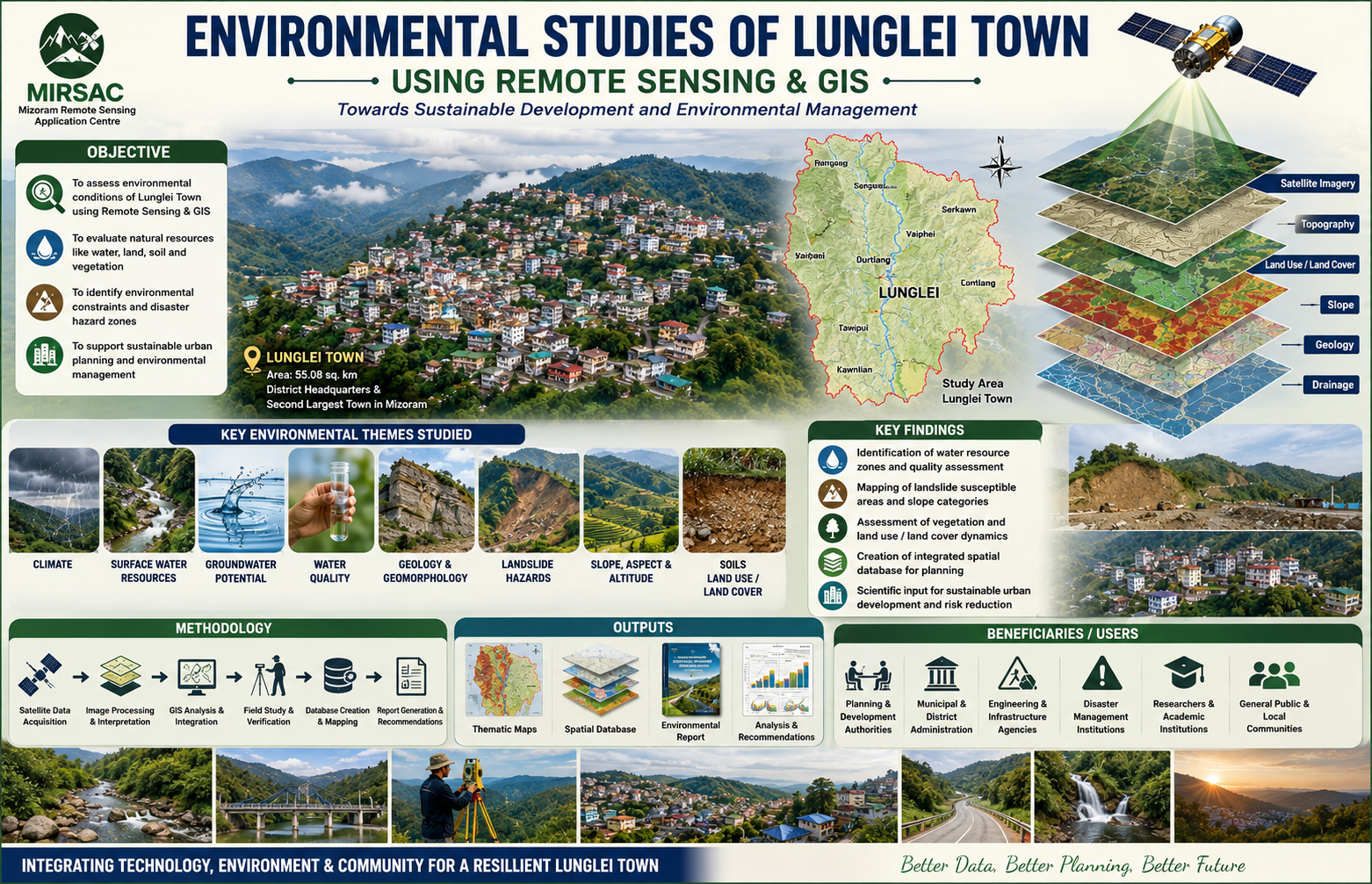
The Environmental Studies of Lunglei Town project was undertaken by the Mizoram Remote Sensing Application Centre (MIRSAC) under the Science, Technology & Environment Wing, Planning Department, Government of Mizoram, and completed in 2008. The study was initiated in response to increasing developmental pressure and environmental concerns in Lunglei, including heavy rainfall, unstable slopes and rock formations, seasonal water scarcity, vegetation degradation and uncontrolled human activities. The project recognized the need for a reliable environmental database to support more scientific and sustainable urban development. The study covered Lunglei Town, the headquarters of Lunglei District and the second-largest settlement in Mizoram, with an area of about 55.08 sq. km. The project applied Remote Sensing and Geographic Information System (GIS) technologies, supported by field investigations and other environmental datasets, to analyse the interrelationships between natural conditions and human activities. The major themes examined included climate, surface-water resources, groundwater potential, water quality, geology, geomorphology, landslide hazards, slope, aspect, altitude, soils and land use/land cover. The study also aimed to formulate recommendations for environmental management and future development planning. The project provides an integrated environmental framework for understanding the physical constraints and resource potential of Lunglei Town. Its thematic maps, spatial database, field observations and accompanying report are valuable for urban and infrastructure planning, water-resource management, landslide-risk reduction, land-use regulation, environmental conservation and identification of suitable areas for future development. The generated information is particularly useful to the Planning Department, municipal and district authorities, engineering and development agencies, disaster-management institutions, researchers and other government departments requiring reliable environmental baseline data. By bringing multiple environmental parameters into a common geospatial framework, the project provides an important reference for monitoring environmental change and promoting safer, better informed and more sustainable development of Lunglei Town. Summarize Metadata Mapping Scale: 1:10,000 Satellite data & Year: ResourceSat – LISS IV (2007) & Cartosat-1 (2006) Study area: Lunglei town Collaborating/Funding Agency: Science & Technology wing, Planning Department No. of Report(s) published: 1 Project Period: 2007 – 2008
Mapping of Agriculture/Horticulture Potential areas within R.Tut Riverine Reserve Forest, Mamit District using Remote Sensing and GIS
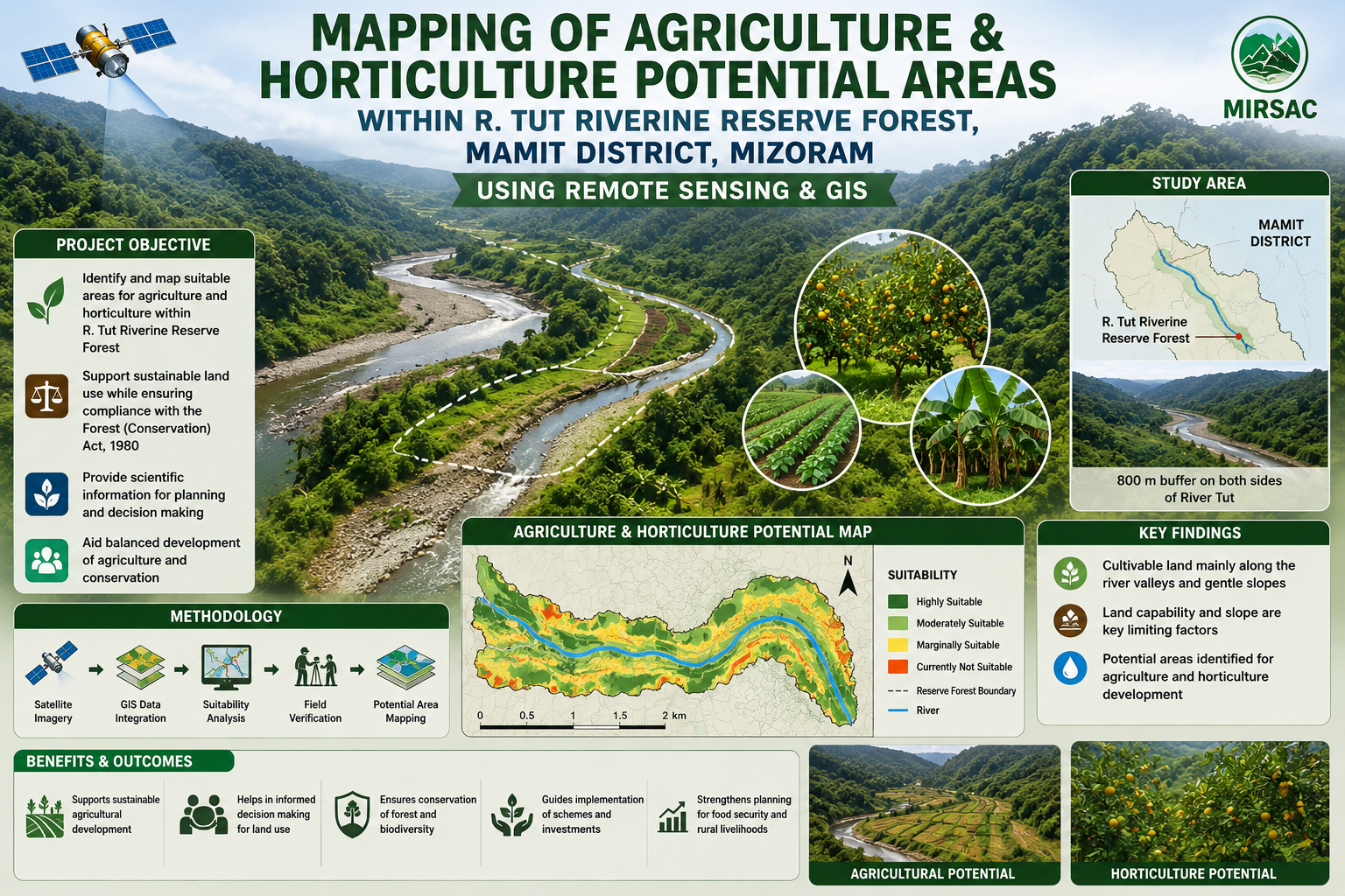
The project “Mapping of Agriculture and Horticulture Potential Areas within R. Tut Riverine Reserve Forest, Mamit District, Mizoram using Remote Sensing and GIS” was undertaken by the Mizoram Remote Sensing Application Centre (MRSAC) under the Science & Technology, Planning Department, Government of Mizoram, with sponsorship from the Environment and Forest Department, Government of Mizoram. The study was initiated following consultations with forest authorities to identify cultivable land within the legally protected riverine reserve while ensuring that any proposed diversion or utilization complies with the provisions of the Forest (Conservation) Act, 1980. The study area covers the River Tut Riverine Reserve Forest in Mamit District, extending approximately 800 metres on both sides of the river. Mizoram’s rugged terrain offers limited scope for large-scale agriculture, making the low-lying valleys and riverbank areas especially important for crop development. The main objective was therefore to identify and spatially delineate land suitable for agriculture and horticulture and provide a scientific basis for evaluating future land-use proposals. The project integrated satellite remote sensing, GIS analysis, Survey of India topographic maps, collateral information and field verification. Thematic datasets on land use and land cover, slope and land capability were generated and overlaid to identify potentially suitable areas. Inputs and field-level guidance were provided by the Environment and Forest Department, Mamit Forest Division and the district Agriculture authorities. The resulting maps, sector-wise spatial database and accompanying report provide an important planning resource for forest administrators, agriculture and horticulture departments, district authorities and development agencies. They can support crop-development planning, land capability assessment, field verification, evaluation of forest-diversion proposals and identification of appropriate compensatory conservation measures. The project demonstrates how Remote Sensing and GIS can help balance agricultural development with forest protection by supplying objective, location-specific information for transparent and environmentally responsible decision-making. Summarize Metadata Mapping Scale: 1:50,000 Satellite data & Year: IRS 1D – LISS III (2006); Cartosat-1 (April & December, 2006) Study area: Tut Riverine Reserve Forest, Mamit district Collaborating/Funding Agency: Environment & Forest Department, Government of Mizoram No. of Report(s) published: 1 Project Period: 2007 - 2008
Mapping of Potential areas for Wet Rice Cultivation in Mizoram
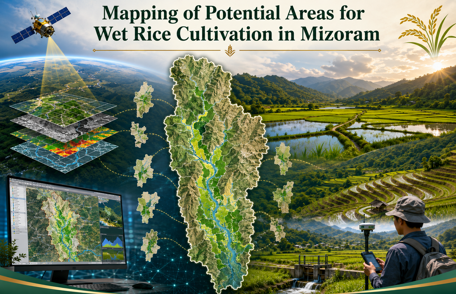
The Mapping of Potential Areas for Wet Rice Cultivation in Mizoram using Remote Sensing and GIS was undertaken as an in-house project by the Mizoram Remote Sensing Application Centre (MRSAC) under the Science & Technology, Planning Department, Government of Mizoram, and completed in 2008. The study was initiated to address the limited availability of level and gently sloping land suitable for wet rice cultivation in Mizoram’s predominantly mountainous terrain and to provide reliable spatial information for strengthening food-production planning. The project covered the entire State of Mizoram and examined all eight districts. Its main objective was to identify, delineate and digitally map potential wet rice cultivation areas, together with supporting thematic information on slope and land use/land cover. The study used IRS-1D LISS-III satellite imagery with 23.5-metre spatial resolution, Survey of India topographic sheets at 1:50,000 scale, ancillary records and field observations. Image processing and interpretation were carried out using ERDAS Imagine, while spatial integration, analysis and map preparation were undertaken through ARC/INFO GIS. Field verification, handheld GPS observations and local information from Village Councils were used to validate doubtful or inaccessible locations. The outputs were designed primarily for the Agriculture Department, Minor Irrigation Department, district planning authorities and other development agencies involved in land development, irrigation and agricultural infrastructure. The district-wise and statewide maps provide a common scientific reference for identifying priority valleys, river plains and foothill areas where wet rice cultivation and irrigation development may be feasible. The report and digital database are useful for planning new irrigation schemes, improving existing wet rice areas, assessing accessibility and infrastructure requirements, prioritizing field investigations and preparing area-specific agricultural programmes. They also provide a baseline for future updating with higher-resolution satellite data. Overall, the project demonstrates how Remote Sensing, GIS and ground verification can support more objective, efficient and location-specific planning for enhancing rice production and improving food security in Mizoram. Summarize Metadata Mapping Scale: 1:50,000 Satellite data & Year: IRS 1D – LISS III (2006) Study area: Mizoram Collaborating/Funding Agency: Mizoram Remote Sensing Application Centre No. of Report(s) published: 1 Project Period: 2007 – 2008