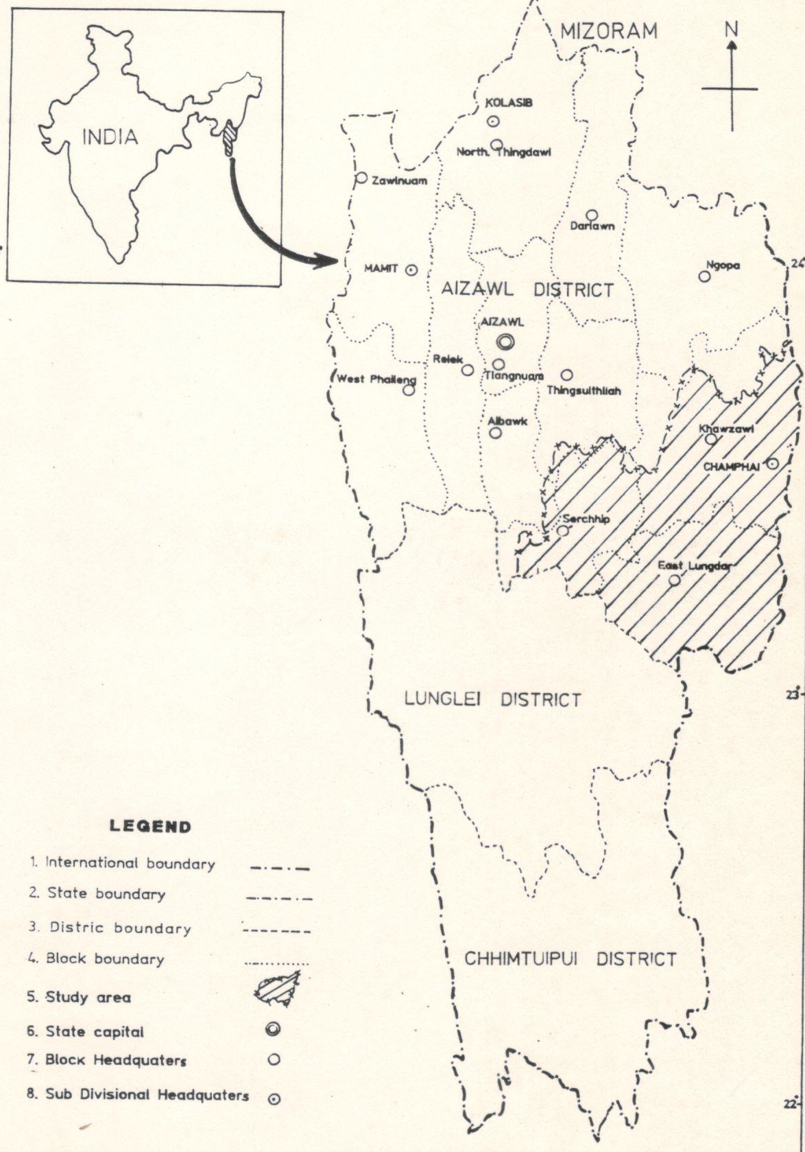
Integrated Mission for Sustainable Development (IMSD) Tuipui Watershed, Aizawl District, Mizoram.
This report presents the Integrated Mission for Sustainable Development (IMSD) pilot implementation for the Tuipui watershed (Aizawl District, Mizoram), executed as a district-scale, multi-thematic, remote-sensing and GIS-based assessment to generate implementable, location-specific action plans for sustainable resource management. The principal objective was to demonstrate how satellite-derived thematic layers integrated with field surveys and socio-economic data can be used to diagnose land-resource status, prioritise interventions, and guide sectoral actions in forestry, agriculture, soil and water conservation, and livelihood enhancement within a watershed planning framework. The study was implemented as a phased, district-focused IMSD activity under technical guidance from NRSC/ISRO and with state collaboration through MIRSAC. It emphasized replicable methods, institutional capacity building, and production of GIS-ready datasets for operational planning. The methodology combined multi-temporal satellite image interpretation, thematic classification, and GIS overlay analysis with stratified ground surveys and stakeholder consultations. Core thematic maps produced included land use / land cover, slope and erosion susceptibility, soil types, hydrogeomorphology and drainage, groundwater potential zones, transport and settlement networks, and existing land-based infrastructure. These were integrated with socio-economic indicators and local needs assessments gathered through field visits to generate a set of area-specific recommendations. Standardized field-validation and mapping protocols were followed to ensure thematic consistency and to calibrate remotely sensed signatures against on-site observations. Key outcomes demonstrate the operational value of the IMSD approach for watershed planning. The project produced detailed, map-based diagnostics of resource distribution and degradation hotspots within the Tuipui catchment covering a pilot implementation area of 940 sqkm, enabling spatial prioritization of interventions such as priority afforestation/regeneration sites, slope stabilization and soil-conservation measures, targeted fodder and livelihood development zones, and water-harvesting and groundwater recharge locations. The integrated analysis identified areas with high erosion risk and soil vulnerability, delineated zones of limited versus moderate groundwater potential, and highlighted settlement patterns and transport constraints that influence service delivery and intervention feasibility. The maps and GIS layers were packaged as decision-support products intended for direct use by the Planning Department , forest and watershed agencies, and local implementing units within the Khawzawl & East Lungdar Rural development block administrative jurisdiction. From a methodological standpoint the pilot study confirmed that remote sensing, when combined with systematic field validation, provides robust spatial coverage and repeatable workflows suited to district/watershed planning. The study highlighted several practical lessons: the need for high-resolution imagery or finer temporal sampling to resolve smallholder mosaic plots; the importance of stratified field sampling for accurate soil and hydrogeomorphic classification; and the benefit of close coordination with local stakeholders to align technical recommendations with ground realities. The report also presents a set of prioritized, site-specific action plans (forestry regeneration targets, soil-and-water conservation measures, fodder development and agricultural/horticultural interventions), together with implementation notes and institutional responsibilities to support follow-through.In conclusion, the Tuipui watershed pilot under IMSD delivered an integrated geospatial baseline and practical action plans that translate multi-thematic remote-sensing products into operational interventions for sustainable watershed development. Detailed quantitative results, including mapped area statistics by theme, priority site lists, and field-derived metrics that underpin the recommendations, are provided in the report and should be consulted for operational planning and monitoring purposes.Summarized MetadataMapping Scale: 1:50,000Satellite data & Year: IRS 1D, 1994-1995Thematic sub-category: Land & Water, Geology, Spatial PlanningCollaborating/Funding Agency: NRSC Hyderabad, RRSC Kharagpur & Department of SpaceReport Publication Month/Year: December, 1995
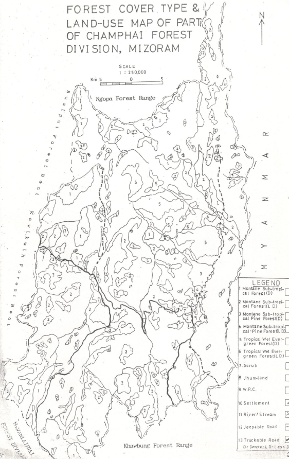
Studies on dynamics of Shifting Cultivation and its influence on forest ecosystem by Satellite Remote Sensing techniques
The project report authored by Dr.R.K.Lallianthanga, MSRSC investigates the spatial and temporal dynamics of shifting cultivation (jhum) and its ecological influence on forest ecosystems, with the dual aim of (1) testing the capability of satellite remote sensing and GIS to detect and quantify jhum cycles in the study area, and (2) linking remotely-sensed land-cover change with on-the-ground ecological indicators (vegetation structure, species composition and biomass/productivity). Initiated as an in-house study at MSRSC, the work combines multi-temporal satellite imagery, image classification and change-detection techniques with stratified field sampling (phytosociological surveys, biomass estimation and fallow-age stratification) to establish an integrated picture of how jhum practices alter landscape structure and ecological condition of forests over time. The project area covers part of Champhai Forest division. The study area was selected so as to exclude bamboo forests and confine studies in Montane sub-tropical forests and Tropical Wet Evergreen forests. Methodology employed multi-temporal Landsat TM image analysis to delineate land-cover classes relevant to jhum dynamics (active cultivation, recent clearings, multiple fallow classes, regenerating vegetation and closed forest). Imagery interpretation and GIS processing were used to map patch boundaries, compute area statistics, and produce time-series maps showing transitions between classes. The remote sensing analyses were calibrated and validated using field observations: plots stratified by fallow age were sampled for species composition, stem density, and aboveground biomass; these in-situ measurements were used to interpret remotely sensed signatures and to assess recovery trajectories across different fallow durations. The report documents the classification approach, sampling design, and the protocols used for biomass and productivity estimation.Principal outcomes demonstrate that multi-temporal satellite data, when combined with targeted field validation, can reliably identify shifting cultivation patches and distinguish fallow classes in Mizoram’s complex terrain. The study produced thematic LULC maps showing the spatial distribution of active jhum, recent clearings and regenerating fallows, together with GIS-ready datasets and area statistics for each mapped class. Field-based phytosociological results indicate progressive recovery of vegetation complexity and biomass with increasing fallow age; species composition shifts from early-successional herbs and shrubs in newly abandoned sites to progressively woody and structurally complex stands in longer fallows, consistent with measured increases in aboveground biomass and stem density. The report also outlines observed relationships between fallow age and key ecological metrics (documented in tabular form), and discusses implications for carbon stock recovery, soil conservation and biodiversity conservation in jhum mosaics.The study highlights both the strengths and limitations of the applied approach. Remote sensing provides robust spatial coverage and repeatability for monitoring jhum at landscape scale, but classification accuracy is constrained by small patch size, steep slopes and mixed land-use signals. Such inherent issues alleviated by higher temporal resolution imagery and systematic field calibration. The report concludes with practical recommendations for operational monitoring (preferred temporal resolution, field-validation density, and fallow-age stratification), and positions the products as baseline datasets for planners and forest managers engaged in sustainable land-use interventions. Summarized MetadataMapping Scale: 1:250,000Satellite data & Year: Landsat TM, Multi-temporal prior to 1993Thematic sub-category: Forest, Shifting CultivationCollaborating/Funding Agency: Mizoram State Remote Sensing Application Centre (MSRSC)Report Publication Month/Year: April, 1993
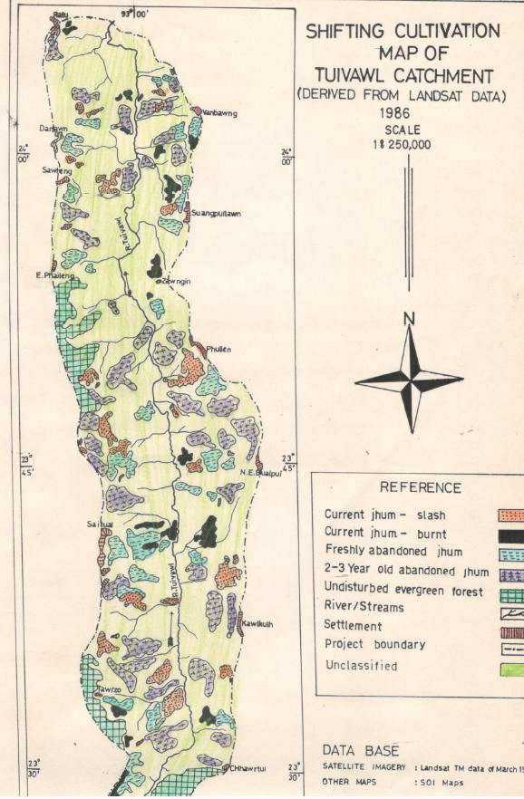
Analysis of Shifting Cultivation dynamics using Remote Sensing techniques & Status Report on Flora and Fauna of Tuivawl Catchment, Aizawl District, Mizoram.
The report authored by Pu Lalnunsiama Colney, MSRSC produced under the in-house initiative “Study of Shifting Cultivation Dynamics using Satellite Remote Sensing Techniques”, presents a focused, catchment-scale assessment of shifting cultivation (jhum) practices in the Tuivawl catchment of Aizawl District, Mizoram, with the explicit aim of jhum dynamics in Tuivawl catchment area using Landsat TM satellite data. The study concentrates on the cyclical land-use processes that define shifting cultivation - clearing, cultivation, abandonment and fallow regeneration - and evaluates how these phases are represented in multi-temporal remotely sensed imagery when interpreted with geospatial techniques and supported by local knowledge. Satellite imagery constitutes the principal data input. Imagery was processed and analysed using GIS workflows to delineate land-cover classes relevant to jhum dynamics (active cultivation, recent clearings, fallow stages, regenerating vegetation and relatively stable forest). The methodology adopted in the study includes visual interpretation of satellite imagery (Landsat TM) from 1986 and 1989, focusing on color tones to identify cultivation stages. The area affected by jhum cultivation was approximately 11,860 hectares (13.58%) in 1986 and 12,620 hectares (14.46%) in 1989. Current jhum areas were identified as 2,480 hectares in 1986 and 2,620 hectares in 1989. Freshly abandoned jhum areas were 2,540 hectares in 1986 and 2,740 hectares in 1989. The study highlights the ecological impacts of shifting cultivation and the need for sustainable alternatives. Multi-temporal comparison of images enabled the identification of land-use transitions and the estimation of temporal patterns consistent with fallow-cycle behavior. Ancillary spatial data and field observations were used to refine thematic assignments and to resolve mixed or ambiguous signatures that commonly arise in smallholder, mosaic landscapes and steep slopes. The methodological emphasis is on establishing repeatable, institutionally adoptable procedures for mapping jhum at catchment scale rather than producing a single, one-off inventory. A notable component of the report is an ecological status note describing local flora and fauna within the Tuivawl catchment. The report lists various species of animals, birds, and reptiles found in the Tuivawl catchment, emphasizing the need for conservation efforts. This section contextualizes remote observations by linking landscape-scale changes with on-the-ground biological conditions, thereby strengthening the ecological interpretability of remotely sensed change signals. By integrating species-level and habitat information with mapped land-cover transitions, the study offers a more comprehensive picture of how shifting cultivation interacts with biodiversity and habitat condition at catchment scale.Overall, the analysis demonstrates that remotely sensed multi-temporal analysis, when combined with local knowledge and targeted field checks, can produce operationally useful information on shifting cultivation dynamics at catchment scale. The study serves as both a methodological test case and a baseline spatial record for the Tuivawl catchment.Summarized MetadataMapping Scale: 1:250,000Satellite data & Year: Landsat TM, 1986 & 1989Thematic sub-category: Shifting Cultivation, WatershedCollaborating/Funding Agency: Mizoram State Remote Sensing Application Centre (MSRSC)Report Publication Month/Year: April, 1991
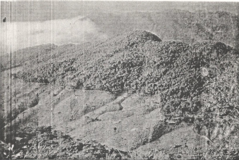
Land Use / Land Cover of Aizawl District, Mizoram
The Land Use / Land Cover (LULC) mapping of Aizawl district was undertaken to generate a systematic and spatially consistent assessment of land use patterns across the district using remote sensing and GIS techniques. The project aimed to establish a reliable geospatial baseline that would support district-level planning, environmental monitoring, and sustainable resource management in one of Mizoram’s most rapidly transforming regions. The primary objective of the project was to identify, classify, and map the major land use and land cover categories prevailing within the administrative boundary of Aizawl district. The study sought to produce standardized thematic maps and associated spatial statistics that could be readily used by line departments, planners, and researchers. Emphasis was placed on creating a uniform and replicable dataset that could also serve as a reference for future land use change studies.Satellite remote sensing data formed the core input for the analysis, supplemented by GIS-based spatial processing and interpretation. Summarized abstract of Land Use/Land Cover in the district: Built-up land: 5,062.5 ha (0.40% of total area).Agricultural land: 3,286.5 ha (0.26% of total area), primarily Kharif crops. Forest land: 1,168,485.5 ha (92.82% of total area), including evergreen and bamboo forests. Water bodies: Major rivers and streams, with ongoing dam construction for hydroelectric power.Others: Shifting cultivation (53,062.5 ha, 4.21%) and abandoned jhum/shrubs (29,112.5 ha, 2.31%)Summarized MetadataMapping Scale: 1:250,000Satellite data & Year: Landsat TM, 1989Thematic sub-category: Land Use, Land Cover Collaborating/Funding Agency: National Remote Sensing Centre (NRSC), HyderabadReport Publication Month/Year: March, 1990
Land Use / Land Cover of Lunglei and Chhimtuipui Districts, Mizoram
The Land Use / Land Cover assessment for the two southern study districts, namely - Lunglei and Chhimtuipui, provides a concise, map-based inventory of prevailing land cover types and their spatial distribution using remote sensing and GIS techniques. The project’s primary aim was to classify and map major land use categories within these district boundaries to produce a reliable geospatial baseline for district planning, resource management, and environmental monitoring. Satellite imagery formed the principal data source, interpreted and processed to create thematic LULC maps, area statistics, and GIS-ready datasets suitable for integration with infrastructure and hazard layers. Summarized abstract of Land Use/Land Cover in the study districts:In Lunglei district, built-up land is 1,750 ha (0.38%), agricultural land is 127 ha (0.03%), and forest land is 430,218.5 ha (94.81%). In Chhimtuipui district, built-up land is 1,062.5 ha (0.27%), agricultural land is 3,187.5 ha (0.80%), and forest land is 358,237.5 ha (90.51%). Summarized MetadataMapping Scale: 1:250,000Satellite data & Year: Landsat TM, 1989Thematic categories: Land Use, Land Cover Collaborating/Funding Agency: National Remote Sensing Centre (NRSC), HyderabadReport Publication Month/Year: March, 1990